Showing posts with label mountain charlie. Show all posts

Tuesday, July 31, 2012

2012 Santa Cruz Mountains Challenge

100 miles, 11000 feet elevation

10:05 total time (8:35 on the bicycle)

5200 estimated calories burned


I have done only one century this year, which is fewer than usual.  I just have not had the time.  But I wanted to make sure to do at least one more, and I always try to do the Santa Cruz Mountains Challenge.  So I decided to do it again this year.  That makes this the fourth time I have ridden it.

Here is a video summary that the organizers published from last year.  I actually appear in it at the 0:40 mark.  We did the same route this year, so all the sights and sounds would be similar.
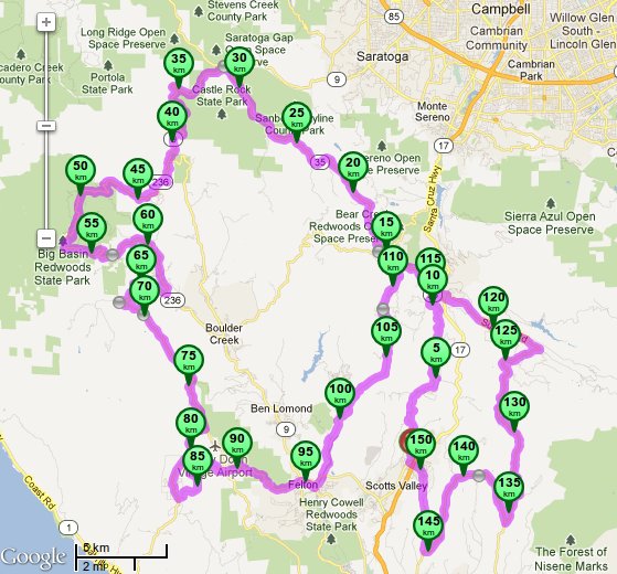
Route Map.

One concern I had was whether my back would give me problems.  I hurt it two weeks ago and was having back spasms for two days.  It was bad enough that I could not stand up straight.  The weird thing was that I did not know exactly how I hurt it.  Previous times when I experienced the same thing, it was after picking up one of my kids awkwardly or some similar strain.  It had been totally okay for a week, including during a couple training rides.  But this ride is much more intense and long that those, so I was apprehensive.

6:35am, 0 miles, 0 feet total

I woke up at 4:10am to get ready.  I had set my alarm for 4:15 but woke up on my own before it went off.  I prepared and left home at 5:40, arriving at the start in Scotts Valley at 6:20.  I parked, got all my things ready, registered, was under way at 6:35.  The forecast was for a warm day, but it was cool and foggy at the start.  That was okay for me because the route starts immediately with a significant climb which warmed me up. It became clear and sunny at the top as we broke through the fog layer.

After climbing to Summit Road, the view back down towards the start location shows the thick blanket of fog shrouding the valley.

About 10 miles into the route, I developed pain in my left knee, which is unusual.  But that is my bad knee, so an injury is within the realm of possibility.  However, the pain was never significant.  It was enough to be noticed, but not enough to bother me.  It was something I had to pay attention to.  If it got worse then I would have to consider abandoning the ride.


The remaining stretch to the first rest area was a relatively gradual 1000 foot climb with several up and down sections.  I had no problems, but kept a slower pace to conserve energy.

8:30am,  26 miles,  3500 feet total


I arrived at the first rest area and proceeded to consume some snacks.  I had a half bagel with jelly, two fig newtons, and a handful of peanut M&Ms.  Normally the peanut M&Ms are something I could just inhale.  But trying to eat them quickly at that time was actually rather difficult.  I heroically managed to finish them.  I wanted to keep this stop brief, and it was only 10 minutes.

The next section was a long downhill descent where I maintained 30 miles per hour for stretches.  It went into Big Basin State Park, where there is a gradual climb, a descent, and another small climb.  This led to the next rest stop.

10:10am, 42 miles, 4900 feet total


I wanted to spend more time at this stop because immediately following it was the hardest climb of the route -- Jamison Creek Road.  This time I snacked on zucchini bread, fig newtons, and Ritz crackers.  I made sure to stretch to loosen my back.  It ended up being a 15 minute break.

The first part of Jamison Creek is mostly flat.  However, once the road pitches up, it does it steeply and does not relent until the top.  I kept my pace very slow on the flat part, because I knew I needed all the energy I could muster.

Jamison Creek rises 1470 feet in just over 3 miles.  This is approximately the height of the top floor of the Willis Tower (formerly called the Sears Tower) in Chicago.  Imagine building a spiral ramp along the outside of the Willis Tower to ride a bicycle to the top.  To match the distance of Jamison Creek, this ramp would have to wrap around the building 18 times.  That means each revolution (going around all four sides of the building) on this spiral ramp would take you up 6 floors.  I managed to cover this distance/height in under 35 minutes, but most of the other cyclists did it faster.  I do not know if that helps to visualize the scale of the effort, but it was a mathematical exercise I pondered while riding up.

I had two questions as I was pushing myself on the climb: how would my knee and my back hold up?  Surprisingly, the knee felt no different.  Even though I was using all my leg strength to propel my self at only 3 to 4 miles per hour, this tremendous strain was not affecting it.

My back started out fine, but I started feeling some lower back strain.  This is normal, since the maximum effort to spin my pedals often creates some strain there.  But I was concerned given the scale of my earlier injury.  I actually felt the same strain on my last training ride.  That time I stopped as a precaution, but found that the strain went away immediately.  This time I thought I should push on, as long as I was not feeling the pain increase.  I was tempted to stop to just catch my breath, but I knew I would have been disappointed in myself unless that was absolutely necessary.

I eventually reached the top and finished with a strong push.  Quite a few riders were waiting at the top to regroup with the other friends they were riding with.  I pulled over to assess my situation.  My back felt fine, but I got hit with a sharp wave of dizziness and a sudden headache.  One of the ride volunteers was nearby and started to chat with me.  I talked to him for a few minutes, which also let the dizziness clear.  I then headed off for the remaining two miles to the lunch stop.  My leg muscles felt completely shredded, but I would soon be able to assess what sitting and eating would restore.

11:20am, 50 miles, 7000 feet total


The lunch was the same as what they usually have: make-your-own sandwiches.  I took two slices of bread, added a lot of mustard, two tomato slices, several rings of red onion, three slices of cheese, and several pickle slices.  I also took a few small boiled red potatoes and salted them well, and grabbed a cookie.  I also got a can of Pepsi to drink.  I always carry Tylenol in my bicycle and so I took that for my headache.  I rested and ate leisurely.

My plan was to decide at this point whether I had the energy to continue the 100 mile route.  If not, I had the option of truncating to the 100 kilometer route, which skips the last long climb.  My legs felt like they were getting their energy back.  My knee was feeling better.  My back was having no pain.  I decided I should finish the 100 mile route.  I sat for a few minutes after eating to make it a 30 minute stop.

The next stretch was a descent followed by a moderately long but not significantly steep climb.  My legs were clearly drained by the previous climbs.  I had to ascend at a slower pace (and lower gear) than I normally would.  Still, it was not bad enough to make me want to opt for the shorter route.

After a fast, steep descent, we reached the bottom of the final significant climb: Zayante Road.  This is a long (11 miles) climb but it is not continuously steep.  The first couple miles are fairly flat.  There are several very steep parts, but these are not too long.  In between those, it is only moderately steep.  My legs would not let me go too fast, so quite a few other riders were passing me.  I did struggle to reach the top, but I did it without having to stop.  The final rest stop was there.

2:40pm, 76 miles, 9900 feet total


Although the distance was only 75% done, all of the major climbing was done.  What remained on the way to the finish was a long descent followed by smaller climbs.  I rested and ate more boiled potatoes and drank a Coke.  It was a 20 minute rest.

Back to the same general area as the first picture, we see that all of the fog has burned off as the day warmed.

The final stretch had some short climbs to get to the final, long descent.  It was several miles down along with a significant amount of motor traffic.  The speed limit was 40 miles per hour, and I was regularly going 30.  Of course, that meant that cars needed to pass me.  There was not much shoulder, but drivers here are usually courteous to bicyclists, so there were no problems.

At the bottom, we had a couple short climbs to return to the finish.  Normally I would fly up these smaller hills, but my spent legs kept me at a crawl.  Riders continued to pass me, but there were several others that were in the same shape as me.  All along, I was passing a few riders too.  So even though most of the riders were stronger than me, there were still quite a few that were not at my level.

4:40pm, 100 miles, 11000 feet total

I reached the finish and noticed that my time was only 10 minutes slower than last year.  I expected to be even slower than that, so it felt like a victory.  I loaded my bicycle on my car, changed clothes, and headed inside for some dinner.  They had made-to-order burritos, I had one with beans, rice, and cheese.  And it was huge.  I took just a little salad with it.  Afterwards, I had some zucchini bread with a little ice cream.  After that I headed home.

My huge burrito at the finish.  I forgot to take the picture before taking the first bite.

I ate a lot of high calorie, low nutrition foods.  Normally these would be considered "junk food", but on a day with this much exercise they are better described as much needed "fuel". In the end, I burned more calories than I consumed on the day.

Normally I would be pretty tired and would get to bed early.  But this day was different because Vaishali and the kids were returning from their Illinois trip, and I had not seen them for three weeks.  I tried to take a nap but did not fall asleep, which surprised me because I had felt sleepy on the drive home.  Instead, I had some coffee and left at 9:30pm for the airport.  It took some time to get the baggage, so we did not get back home until after midnight.  I fell asleep immediately after getting home.  It was a long and tiring day for me!

I was really happy with my effort this year.  I had not done as much training as previous years, but my time was not significantly slower.  I had some injury concerns, but they did not manifest.  This ride might be the hardest century in this area, which is probably why I like it so much.  I think I will make a point to do it every year, as long as my training keeps me prepared enough.

Sunday, August 7, 2011

2011 Santa Cruz Mountains Challenge

100 miles, 11000 feet elevation
9:45 total time (8:30 on the bicycle)


Almost at the last minute (well, two weeks before the event), I decided to sign up for another century. I have done the Santa Cruz Mountains Challenge (SCMC) twice before. I find it to be one of the harder centuries in the area. It climbs around 11,000 feet elevation, and some of the hills are exceptionally steep.

Following the Seattle to Portland ride, and my increase in training recently, I felt that my conditioning was returning to a level where I could consider the more challenging rides. So, I decided it was worth trying this ride now. There was no unknown about the route. They change the course occasionally, but this year it would be the same as the first time I did it in 2007.

I did make a decision that created a small unknown — my choice of bicycle. I have two road bicycles. I have used both of them for centuries and double centuries. However my older one has lower gearing. I can do steep hills on either one, but I have only used the older one for the very steep hills. That was the one I used for both previous attempts at the SCMC. This time I wanted to try the newer one.

I prepared by riding a training course with exceptionally steep hills on the newer bicycle. I did it without trouble. However, the killer hill on the SCMC route (Jamison Creek Road) is more steep and much longer than any of these. I did not know if I had both the strength and endurance for the higher gearing on that road.

A week before the event, I contacted my friend Gabrielle whom I had not seen for months. I know that she had ridden this event before, so I thought I would check if she was trying it again this year. She replied that she was. It would be nice to meet again.

The starting location is just over a half hour drive from home. I woke up Saturday morning at 4:10am. I had set my alarm for 4:30, but Aasha woke up crying and I decided since I was awake, I would just get up. I got ready and left home at 5:45am and arrived at the start at 6:25am. I set up my bicycle and got registered. Just as I finished the paperwork, Gabrielle came by. She had just arrived so I waited for her and her friend Denise to set up and register.

7:00am, 0 miles, 0 feet total

The forecast was for a mostly sunny day, but we were blanketed in thick fog at the start. It was quite chilly, but I decided that I would not put on my jacket because the course starts with a good climb. Since I had not talked to Gabrielle for quite some time, we chatted as we ascended. I actually kept a faster pace than I normally would have because I kept up with her.

After reaching the summit, the road follows the mountain ridgeline for several miles. It had no extended climbs, but had many ups and downs. Gabrielle sped ahead and I had Denise for company for this stretch. For first half of this part, the road was wet, as if it had rained. The moisture was from all the fog condensing on the overhead trees.

9:00am, 26 miles, 3500 feet total

We all regrouped at the first rest area. It was warm at the stop but we did not linger too long. We left together for an extended downhill run. It was considerably cold, which was a bit of a surprise considering how warm it was at the top. After entering Big Basin State Park, the road has a series of up and down stretches, none too long. Again Gabrielle took off during the climbing.

10:30am, 41 miles, 4900 feet total

Denise and I reached the next rest stop expecting to see Gabrielle, but she had already left. This rest stop comes just before Jamison Creek. This is the steep climb that would be a first for me on this bicycle. Most of the chatter among the riders at the stop was about how intimidating the hill is. It is important to fuel up and otherwise prepare for the grueling climb, so I ate well.

I was feeling very cold at this point, but I had wanted to let myself get to that state (I could have stopped and slipped on my jacket at an earlier point). Previous times, I had overheated on Jamison Creek, so I wanted to start out cold.

I started the climb with a slow and steady pace. As the road hit and sustained its steepest parts, the deliberate pace was not an option. It still was slightly faster than what I would have done on my other bicycle. The lowest cadence I can pedal with my legs is about 60 turns per minute. So given that first gear on this bicycle is a little higher, I necessarily would be going faster than in first gear on the other. This also means I am forced into a greater effort than I would have on the other.

Fortunately, it was not a struggle. Although several cyclists passed me on this stretch, I passed several others. The sun broke through and the air became warm halfway up, but I was in no danger of overheating since I started with shivers at the bottom. I reached the top without feeling exhausted, and Gabrielle was waiting (she had been there for a while). A few minutes later, Denise joined. We left together to the lunch stop that was only a couple miles away.

11:45am, 50 miles, 7000 feet total

I still felt relatively fresh given that half the distance and most of the elevation was done. I ate a big lunch and rested for a little while. We three left together but our paths diverged a few miles down the road. Gabrielle and Denise were doing the 100 km route, which heads back to the finish at this point, whereas my 100 mile route adds another long climb. We said our goodbyes and I thanked them for the great company.

The next section included several shorter climbs before the last big one. I was passed again be a group of guys whom I had seen earlier. It seemed that they were stronger riders than I, considering our differences in speed. But it also seemed that they would periodically stop and regroup, at which time I would pass them. Our total average speeds seemed exactly the same.

1:20pm, 64 miles, 7900 feet total

There was an unofficial stop at a local park before the final big climb. I was the only rider to pause there at that time, but I thought it was a good spot to fill my water bottles and have a quick bathroom break.

Next up was Zayante Road, which I had last ridden four years ago. As I remembered it, it was a 10 mile climb where the first half is relatively flat and the second half is fairly steep. There was a small water stop just before the road becomes significantly steep. I did not need to stop because I had filled up recently. The same group of riders passed me early in this stretch of road, only to get passed by me when they paused at the water stop. By now I nicknamed them "the hares", after the famous tortoise and the hare fable.

2:50pm, 76 miles, 9900 feet total

I reached the final rest top just past the top of Zayante tired but not exhausted. I was having stiffness in my neck and back, so I spent a little extra time stretching. The next section contained a long downhill. Approaching that, the hares passed me but then paused to regroup and clear up some confusion about the route only to have the tortoise (me) pass them.

At the bottom of the hill, we were close to the end, but still had a small climb. Again, there was a small water stop which I skipped, but at which the hares stopped. This would be the last time I saw them.

4:50pm, 100 miles, 11000 feet total

I arrived at the end feeling good. It was satisfying knowing that I had finished one of the hardest centuries in our area without any serious problems. I was hoping to have a lower overall time the my previous attempts, but I had practically the same time as last year. Still, that was not a disappointment.

This year has seen me increase my conditioning to a level I have not had in three years. Considering that I have been able to do regular trainings, and that I have done some difficult events, I am wondering if I should attempt some even bigger challenges. There is a chance I may try to do a double century this year.

Sunday, August 1, 2010

2010 Santa Cruz Mountains Challenge

100 miles, 10225 feet total elevation,
9:45 total time (8:30 on the bicycle)

I did this century three years ago, and I have wanted to do it again ever since. I was barely able to finish that time due to exhaustion. I wanted to redo it and finish strong, but each year I had a schedule conflict. This year my weekend was free, but I did not think I had the necessary training.

This is probably the hardest 100 mile ride that I have ever done, due to the total elevation and the steepness of the hills. The Death Ride is comparable since it has a similar ratio of elevation to miles. The Death Ride is 40% longer, but the Santa Cruz Mountains Challenge has steeper hills.

In spite of my lack of training, I decided to give this ride a try. I have a good familiarity with the roads in the area, and there are options for cutting the ride short if needed. I knew it would be difficult, but my goal was simply to finish without too much struggle.

6:45am, 0 miles, 0 feet total

I woke up at 4:45am and left home by 5:45am. I made the 45 minute drive to Scotts Valley, the start of the ride, which is near Santa Cruz. It took extra time to get registered because they did not have my name on the list of riders. Because I registered online and paid with Vaishali's PayPal account, they had her name on the list instead of mine. Once that confusion was cleared, I started.


The route was counter-clockwise, starting and ending in Scotts Valley.

It was distinctly cold at the beginning. Scotts Valley was shrouded in a thick blanket of fog, and the early morning sun was not heating up anything. Although my teeth were chattering, I was happy to experience this. One of the main reasons for my struggles three years ago was the heat. We have been having a cold summer this year and today was typical. A cool day meant it was less likely for me to overheat on the climbs. As soon as I started uphill on Mountain Charlie Road, the first major climb, I warmed up. By the time I reached the summit, we were above the fog layer and the bright sun was warm. (Usually the mountaintop is colder than the valley, but not today.)

There was a water stop at the summit, but I had no need to break there. I immediately began the descent to the town of Boulder Creek, and back to the chill. I did not rest long because I did not want to cool down too much. I made sure to eat some high calorie food (cookie, bagel, banana bread) in preparation for the two steep hills coming up.

8:20am, 21 miles, 2225 feet total

After a couple relatively flat miles, I reached the second major climb of the route -- China Grade Road. Although it is exceptionally steep, it is mercifully short (relatively). The steep portion is only 1.25 miles. I knew I would have little problem with it. My goal was to not push myself too hard and use up too much energy. Several cyclists passed me but I found myself behind one who was going between 3.5 and 4 miles per hour. I was averaging slightly more, and I had an urge to pass him, but I decided to let him pace me and preserve some strength. I reached the summit and immediately continued downhill. This was a mini-loop which took me back to the base of China Grade, and to the next rest stop.

9:50am, 34 miles, 4100 feet total


Again I minimized my rest time and made sure to eat. Now I was to tackle what I expected to be my biggest challenge of the day -- Jamison Creek Road. Last time I did this ride, I could not make it to the top without having to stop. This road is ridiculously steep. The grade is comparable to China Grade, but it is nearly three times as long. My previous effort was hampered by the high temperatures, which totally drained me. This time it was much cooler. To my surprise, I kept a steady pace and was not wiped out when I reached the top. The ride organizers measured everyone on this stretch, and my time was 319 out of 470 riders. Although this is not an impressive percentile, it is better than I thought possible. I was in good spirits when I arrived at the lunch stop.

Reaching the top of Jamison Creek Road.

11:00am, 43 miles, 6000 feet total


I decided to rest here more than I had at the earlier stops. I ate slowly and chatted with some other riders. It was nice knowing that most of the elevation has been done and the two steepest roads were past. I headed out 3o minutes after I arrived. The next portion was a long descent to the Pacific coast. This essentially was continued rest time since I did not have to expend much energy.

After reaching the coast, we headed north along Highway 1 and then turned around. This involved some smaller climbs, and I could tell that my legs were not as fresh as earlier. I pulled into the last rest area. Even though I wanted to eat to fuel up, I had no appetite. The only thing I could manage to consume was a can of soda.

1:15pm, 66 miles, 7125 feet total

We then headed back from the coast on the fourth big climb of the day - Bonny Doon Road. It was my first time on this road, and I had wanted to try it for a long time. For the past two years, this climb was part of the Tour of California (professional bicycle race) route. I did not realize how difficult it was. The three miles of consistent 9% grade was not as steep as China Grade or Jamison Creek, but having used up most of my energy on the previous climbs, this one was hard for me.

Actually my core energy was fine. I did not feel weak or dizzy. The problem was that my leg muscles were fully used up and I could not push myself beyond a slow crawl. I simply kept it in low gear and accepted the slow pace. I could tell that I would have no problem finishing, but that any remaining hills (even the small ones) would slow me down. After this climb, we again headed back to the coast, this time into the town of Santa Cruz. Now my energy level did finally crash. But because I was in the city, it was not an issue. I stopped at a corner store and bought a chocolate bar. I felt the effect almost immediately, and I knew the final moderate hill to the finish would be no problem.

4:30pm, 100 miles, 10225 feet total


I reached the end with great satisfaction. The last time I did it, I was dazed and energy-less. This time I felt good. I ate the dinner provided and then headed home. I usually recover quickly, but the next day my legs were much more sore than usual. I expected this since I really shredded my leg muscles. It was a great feeling of satisfaction knowing that I am still capable of riding strong.

This could be my last century of the year. The remaining ones on the calendar are either too far out of town, or are familiar nearby routes that are not interesting or not challenging enough. Still, there are a couple that I could possibly work into my schedule. I will definitely try some more long rides with friends.

Saturday, August 4, 2007

Santa Cruz Mountains Challenge 2007

100 miles traveled, 10000 feet total elevation gained, 11:30 hours total

I really enjoyed doing the Sequoia Century (read that report here) two months ago. That was the first century I ever did. I thought I should attempt another one this year since I am still in shape for it.

I chose this one because it is more challenging. Although it is shorter, there is more total elevation gained and some steeper slopes.

The quick summary is that I finished it, but just barely. The three big hills combined with the heat were almost too much for me. And nothing unusual happened to me (unlike the last century where I had to help an injured rider who crashed at the railroad tracks).

6:25am, 0 miles, 0 feet

I woke up at 4:00am, left home at 5:30am, and arrived at the starting point, Scotts Valley High School, around 6:00am. There was no traffic at that time, so the 30 mile drive took only half an hour. I got started on the ride at 6:25. The elevation of the start is 700 feet.
The left loop was done counter-clockwise, and the right loop clockwise.

The sun was low and it still was fairly chilly. But I did not put on my jacket because I knew the first big climb (Mountain Charlie Road) was coming up soon. This was the last big hill on the Sequoia Century route and I struggled that time. But this morning it was the first, and I felt fresh and strong. I made sure to keep a slower pace than what my legs wanted so I preserved energy that I was sure to need many miles later.

Quite a few strong riders kept passing me at this point. Although I was tempted to try to keep pace with them, I was content to let them zip by. There was about 5 miles of steep climbing, and several more miles of moderate climbing to come.

7:38am, 11 miles, 2200 feet

I reached the first rest stop. It was a small stop with water and no food. I had plenty of energy at this point and almost decided to skip it like most of the other people riding near me did. But I decided that it would be more sensible to stop, stretch, and refill my water. It was only a one minute stop, so it probably was a sensible decision.

Next was the 10 miles of moderate climbing, which was okay. We passed through the highest elevation point of the route, 3100 feet.

8:30am, 22 miles, 3635 feet

I reached the second rest stop, where they had food and drinks. Here it made sense to take a break and loosen up before the upcoming downhill section, so I stopped for 11 minutes. I ate half a banana, half an orange, and a cookie.

Upon leaving the rest stop and coasting downhill, I encountered something
very unusual. The rest stop is at 2600 feet elevation, and the down grade is steep enough to reach 30 miles per hour even without pedaling. Usually that elevation, plus the wind speed, plus that time of day combine for some very cold conditions. However, I did not feel cold at all. I recognized this as a bad sign — it was going to be a very hot day.

9:33am, 37 miles, 4440 feet

The route took me into Big Basin State Park, at which point the road had both uphill and downhill sections, but nothing too challenging. I stopped that the Big Basin Park Headquarters for a bathroom break. It was not an official ride stop, but having been here before, I knew there was a bathroom I could use.

9:53am, 39 miles, 5010 feet

I reached the third rest stop where I planned to spend a little time, even though I was not particularly tired yet. I was there for 8 minutes, and ate some more orange, banana, and two cookies. This was the last rest stop before the second big climb, the infamous Jamison Creek Road. Most of the conversations I overheard at this stop were people talking about how difficult this upcoming section was. I had actually done the road before. The first time I made it up all the way with no problems, but the second time I had to stop twice to catch my breath.

I was pretty confident that I would not have too much trouble this time. I did not have as much energy as when I started, but still felt fairly strong. The beginning of Jamison Creek starts not too steeply. A couple cars passed me in the opposite direction, and as soon as they passed I smelled the acrid, sulfuric odor of burned brake pads. That is pretty common because the top of the road is about two miles of nearly 12% average grade.

I started out well, at a slow and steady pace. After entering the steep section, the difference in speeds between all riders was greatly reduced. A lot of people were keeping the same 4 miles per hour pace that I was. I passed a few, but since I was barely going faster than them, I could chat with them briefly as I went by.

As I got further into the climb, it became more difficult. I was starting to feel the heat. Besides drinking my water, I was squirting it on my back and my chest to help cool off. My heart rate was high, and my breathing was labored, although I was not yet panting. I really wanted to make it to the top without stopping, but that possibility was diminishing. Finally, I started feeling light-headed and decided that the best choice at this point was to stop. I pulled over to the side of the road where there was some shade and stood there for two minutes. After that, I was able to continue the final half mile to the top.

11:10m, 46 miles, 6460 feet

The fourth rest stop was at the top of Jamison Creek Road. Although the lunch stop was only two miles away, most people needed to stop here. I was amazed at some of the strong riders who flew up Jamison Creek and did not even stop here. I stood at this point for about 8 minutes. I recovered some strength, but not much. It was clear that this climb drained me.

The two miles from the water stop to the lunch stop had only some moderate uphill sections, but in my weakened state, I found them difficult. I was not alone. A couple other riders kept pace with me. We rode at a normal pace on level ground, but struggled on the slight inclines. Clearly, my body's accessible energy reserves were completely exhausted. This was a good time for lunch, which was held at a California Department of Forestry fire station.

11:35am, 48 miles, 6815 feet

Well, there was a problem with the timing of lunch. After pulling into the lunch stop, I felt dizzy and nauseous after parking my bicycle. This is a clear sign of exhaustion. I walked around briefly before going into the building where they were serving the food. Although I desperately needed energy, the idea of putting food in my mouth was unpleasant.

I made a cheese sandwich and took a small potato and a can of cola. I slowly ate the sandwich, taking small bites and trying not to overwhelm my system by going through it too quickly. I took a bite out of the potato, but it was not fully cooked and soft. It was edible, but I thought it may not get digested with my system in the state that it was in, so I left it. I returned to the food line for two cookies, which were easier to eat. I could feel some energy returning, but was still generally drained.

I had another common symptom of exhaustion: I felt sleepy. As long as I felt this way, I knew I would not be able to go much further. I put my elbows on the table and held my face in my hands. I closed my eyes and rested like that for about 10 minutes. I did not really fall asleep, but I did get some good rest doing that.

After that, I thought about continuing. Different people came and left the table where I was seated during lunch. I chatted with them briefly. In all, I was at this stop for one hour, which is how long I thought I needed to rest and digest the food. Now I had to decide how to continue. If I really had no more energy, I could abort the ride I planned (the 100 mile route) and do the 100 km route. That involved no more climbs, and followed a mostly downhill route back to where we started. To this point both routes proceeded together, but five miles down, they split, rejoin, and split again.

By this point I felt much better. Quite a lot of my energy had come back, but I knew that having reached this level of exhaustion meant that I could get drained again very quickly. I knew that I did not have to abort immediately. I could do the split and rejoin and decide at that point how I felt.

I pushed off and took a very slow pace. The road had very moderate inclines and declines, but more of the latter. I took the split for the 100 mile route, which added a descent and climb that I had no problem with. When I rejoined, I felt like I was strong enough to do the full course, as planned.

1:44pm, 63 miles, 7610 feet

A steep downhill ended at Covered Bridge Park, which at 250 feet elevation, is the lowest point of the route. There was a water stop here, but I decided not to stop. The 100 km route split off back to the starting point, and I headed towards the third (and last) big climb of the route.

I had been on the road (Zayante) before, so I knew that it started out fairly flat for a while before increasing in steepness, with a couple very steep sections. This was perfect for me because by keeping a slow pace, I could continue rebuilding my energy reserves before hitting the hard parts. The difficulty of this climb is comparable to the first one (Mountain Charlie), but not as hard as the second one (Jamison Creek). I felt that I had a good chance to make it.

2:30pm, 71 miles, 8440 feet

By this point in the ride, people were bunched in groups that were keeping the same speed. Earlier on, people were fresh and some kept an aggressive pace while others were conservative. Plus the 100 mile and 100 km groups were combined. But now most were on low reserves and keeping a steady pace, plus we only had 100 mile route riders. There was a water stop before the point where the road became steep. I lingered there for a few minutes. I had run low on energy again, but not fully exhausted. I thought it best to allow a little recharging.

The road got steeper, the heat became oppressive, and again I started running low on energy. The stops I made changed from preemptive attempts to maintain energy to mandatory energy recovery stops. I was able to pedal for 10 minutes before having to stop and rest for one or two. Even though the ride up Jamison Creek had exhausted me, this part ended up being the most difficult part of the ride.

3:29pm, 74 miles, 9365 feet

I finally reached the end of Zayante. I needed to continue two more miles to the rest stop. This part of the route was still uphill, but at a lesser grade, so it was not too much of a struggle.

3:42pm, 76 miles, 9545 feet

I dragged myself into the the last fully supported rest stop. My only immediate concern was to rest and recharge. Again, I was nauseous and could not really eat, even though I needed the energy.
I slowly drank a soda and sat mostly motionless and rested. With some effort, I was able to eat a cookie. I really needed the potassium, so I forced myself to eat some orange. I thought I should also have some banana, but I did not think I could stomach it.

Most of the cyclists at this stop were in the same situation as I. This rest stop was scheduled to officially close at 4:00, and the ride as a whole was officially ending at 5:00. I overheard people discussing the same thoughts I was having — whether to continue the full route, or take a shortcut that goes directly to the start/finish. There was a two-fold problem in continuing with the course. First, although it was mostly downhill, it also contained two moderate climbs (and the thought of going uphill again after the recent struggle was not pleasant).

Second, it was 25 more miles, and there was no way to keep a pace to reach the finish by the closing time of 5:00. This is only a problem because there was no guarantee of support vehicles being available to pick up riders who could not continue.

The ride crew had started dismantling the stop, but they were going to linger there longer because there were more riders on the course behind me. I ended up stopping for 30 minutes. In this time I was able to recover a decent amount of energy. I decided that I was going to do the full route. It was about 20 miles until the next climb, and most of the way there was downhill. I figured I could continue rebuilding my energy while I coasted. Several other people who contemplated abandonment made the same decision.

A pair of cyclists started from the rest stop about the same time as me, and we kept nearly the same pace. I would pass them on the inclines, and they would pass me on the descents. The remaining two small climbs turned out to not be too difficult. I did not have to stop at all, but I kept a very slow pace.

6:00pm, 100 miles, 10890 feet

I reached the finish without any problem. It was an hour after the official close, and the parking lot was sparse. I rode directly to the car and immediately put the bicycle on the rack. I walked to the setup area and found they still had some of the food for dinner available, so I ate some mushroom pasta and garlic bread. Plus another soda. I must have had 4 or 5 cans this day. It usually takes me two months to drink that many, since I generally avoid them.

It felt good to be done. I was so glad that I had not cut the ride short. It was disappointing that I struggled so much, but I think I would have been pretty unhappy to not have finished it. I was tired, and my back and neck hurt. My butt had gotten sore but not as much as the last century.

It was a long day. I woke up at 4:00am, left home at 5:30, returned home at 8:00pm, and went to sleep at 9:00. Then I got 10 hours of solid, sound sleep.

I think this is my last century this year. Most of them are organized in the summer anyway. I think I will do one or two next year. My next goal is to do some biking in the Sierra Nevada mountains, which is harder than biking the hills here in the Bay Area. The roads are not necessarily longer or steeper, but they are at a much higher elevation, meaning that oxygen is more scarce.

I have made a lot of progress in increasing my conditioning since I started my serious cycling a year ago. But clearly I have not come close to reaching the levels that are possible. I need to keep training to get closer to what some of the stronger riders could do.

Sunday, June 3, 2007

Sequoia Century 2007

112 miles travelled, 9000 feet total elevation gained, 11:15 hours total

I participated in the Sequoia Century for the first time. A century is any 100+ mile bike ride, but this is one is challenging because of the amount of hill climbing involved. Here is a record of my experience, with the total miles covered and total feet elevation gained noted at each point.


I woke up at 4:15 and started getting ready. I had gotten donuts the previous day so I did not make an early morning trip to get those. I stretched, drank coffee, made an egg sandwich, stretched, got dressed, stretched, ate half a donut, and went over my checklist of all the things to do and take with me.

I woke Vaishali at 5:20 and she only needed a few minutes to wake up and dress before dropping me. She was just going to go back to bed after going back home. Vaishali dropped me at the Palo Alto VA campus at 6:00am just like we had planned. I got everything set up and got started at 6:10. I did not have to do much at registration because I picked up my number the day before.

6:10am, 0 miles, 0 feet

Pretty soon after starting, another cyclist passed me and told me that my gloves were about to fall out of my pocket. That was the only oversight in my preparations -- I forgot to put on my gloves. It was on the cool side, but I chose not to wear my jacket. I knew I would get hot on the upcoming climb up Page Mill Road, plus I think the excitement made me more cold-resistant than usual.

The climb up Page Mill went pretty well. I had done this part of the ride so many times that I knew the road very well. It went along more easily that I was used to, probably because of my excitement and adrenaline. Several people passed me on this stretch, and I only passed a couple others. I warmed up pretty quickly. On one of the flatter sections, I switched from my full-finger gloves to my half-finger gloves while still pedaling.

I settled behind two guys somewhere before the halfway-point of the climb. Their pace was just a little slower that what I thought I could do, but I felt it was best to keep myself limited to that at this early stage.

Just past the halfway-point of the climb, we broke through the fog layer. In the morning everything looked dark and overcast. Vaishali was concerned about the visibility in the hills. But it turned out that the valley was just in a blanket of fog. Above that, it was clear and warmer.

Eventually as we approached the summit, I could no longer take the pace of the guys I was following. I increased my speed and went past them. I reached the summit at Skyline Blvd and continued across on Alpine. This is the point where the 112 and 60 mile routes diverge, so there were fewer cyclists on Alpine.

7:20am, 11 miles, 2280 feet

The downhill ride on Alpine went smoothly. There were very few cars on the road at this time. Once I got back under the fog layer, it started getting cooler. I did not want to put on my jacket because I knew I was getting close to the bottom of the hill, but my hands started getting cold. I need to get the full-finger gloves back on, but there was no way I could do that while speeding downhill. I pulled over to the side and switched them quickly.

Before long I reached the intersection with Pescadero Road. The road started uphill, but fairly quickly got to the entrance to Sam MacDonald Park where the first rest top was. I pulled in and saw that some of the guys who passed me were there. I saw the guy who told me that my gloves were in my pocket. I ate a half banana, some slices of orange and a piece of coffee cake.

8:14am, 19 miles, 2640 feet

I did not want to stay too long and cool off, so I left within 10 minutes. From the park, there was a steady, but not difficult, climb up Pescadero road. After the crest, it was a fast downhill. The fog had burned off by now and it was fairly bright, but it was still early enough that there were still few cars on the road.

Eventually the road leveled off to a more slight grade. As I was nearing the end of the stretch on Pescadero Road, I was passed by the two guys who I rode behind on Page Mill. Just before the town of Pescadero, we turned left towards Butano State Park. The road here is parallel to Highway 1, and is just a little hilly. I caught up to the two guys again once we hit the uphill section. Again, at some point their pace uphill was too slow for me so I passed them.

Before long, the road turned and ended at Highway 1. There were flagmen with the Century helping cyclists turn onto Highway 1 safely. Fairly soon after this point I reached next rest stop at the Costanoa camp ground. There was an even bigger group here than at the last one. I think it was because more people had passed me.

9:11am, 38 miles, 3690 feet

Here again I ate more apple and orange. But for energy this time I had some peanut M&Ms. This time at the facilities I also took off my gloves washed my hands well because they had gotten sticky from sweat and handling the fruit and candy.

Again, I did not want to cool off too much so I left within 15 minutes. As I was leaving Costanoa, I recognized one of the riders who was entering. I used to see him on Caltrain during my commute when I worked at Rearden. At first it struck me as an odd coincidence. But after thinking about it, it probably is not a very big coincidence. Both of brought our bicycles on the train, which means that we are both cyclist. And the Sequoia Century is fairly popular (over 1000 people registered), so it is not too surprising that we are both chose to ride in this event.

The 24 miles on Highway 1 is the longest flat section of the ride. The road does go up and down the sea cliffs a bit, but contain no serious inclines. The northern (first) part of this stretch was much clearer than the rest. I had a tailwind most of the way which made the pedaling on this stretch easier.

Just a few miles after Costanoa, I saw another rest top on Highway 1. This was confusing, but I quickly realized that it was for another event. There were signs on Highway 1 for the AIDS Lifecycle ride (from San Francisco to Los Angeles). That explained why I saw so many more riders on this stretch.

I passed and was passed by fewer people in this stretch since we were all generally cruising at similar speeds (not unusual for a flat stretch). Just before the town of Davenport, I was slowly passed by a woman, and I remained fairly close behind her for a mile or two.

10:15am, 51 miles, 3800 feet

We approached a place where the railroad tracks cross the road. There was a sign put up for the cyclists warning of the tracks. Having ridden on this part of the road before, I felt that the warning should have been bigger and more explicit. Most railroad crossing have the tracks perpendicular to the road. These are not too dangerous, just bumpy. But this particular crossing is treacherous because the tracks are just slightly off the angle of the road.

I slowed down and swerved to the right a little so that I could turn back left and go over the tracks an a perpendicular angle. But I saw that the woman in front of me did not change her angle. I was worried because it looked like a dangerous approach. I was correct because her front wheel got stuck in the track. She went flying and landed hard on the pavement with her bicycle falling on top of her.

I immediately got off my bike, left it by the road side, and ran over to where she was laying. I took the bicycle off her and tossed it to the side. She needed to move because she was laying on the white line that defines the boundary between the road and the shoulder. I was afraid that she may get hit by a car so I immediately began waving my arms and motioning for cars to slow down and go around her.

She was screaming in pain. I told her she needed to move out of the road, but she said she could not move. She remained in the same position as she landed--on her left side and somewhat face-down. I asked her if I could help her move but she said she was in too much pain to move. I thought about moving her myself, but was afraid she may have a fracture that I might aggravate by moving her.

I really did not know what to do next. She needed to move out of the road, but I did not know the best way to do that. Then a car pulled over and two women came by to help. One of them said she was an off-duty paramedic, and it turned out to be good timing that they had come by at that time.

She checked out the rider to see how badly injured she was. After determining that there were no major fractures, the two of us picked her up and moved her all the way to the edge of the shoulder, and by now she was able to sit up on her own.

The paramedic continued to evaluate her. Clearly the cyclist needed medical attention. She offered to call an ambulance for her to take her to Santa Cruz. The cyclist said she preferred to go back to Palo Alto because her parents live there. I told her that I could call the event organizers to see if they could send one of their support vehicles to pick her up. That is what she decided to do since her injuries were not life-threatening.

This whole time there was a decent number of cars and bicycles passing us. At this point, a group of cyclists passed on one caught his rear wheel in the tracks, which sent him crashing to the ground. The paramedic went end attended to him. He landed on his shoulder and smashed it pretty well. But he was able to walk.

It was a very unfortunate result for this guy. He is tourist from Belgium, not a participant in either of the organized rides. He was on his first day of a two week bike tour of the US. It looked like with the extent his shoulder was hurt, it was also be the last day of his trip.

It took about 30 minutes for the support vehicle to arrive. He had a pickup with a bike rack and could easily take both riders back to the starting area in Palo Alto. As we were getting everything prepared on the truck, another woman got her bicycle caught in the tracks and crashed. Fortunately this one was not as serious as the others. She smashed and cut one of her knees. The first two crashes were good advertisements for bicycle helmets. Both of their helmets had large cracks in them, which spared their skulls. Although the third rider might have been able to continue, she decide to not take a chance and just go back with the others. The rack on the truck could take three bicycles, so that is what they did.

After they had left, I was finally ready to continue. I had lost close to an hour because of this episode. All the standing around in the ocean breeze had really cooled me off. So for the first time in the ride, I wore my jacket. The rest of the trip into Santa Cruz was uneventful. I did get hot eventually, but I did not want to stop to take off my jacket. I had lost enough time already, and the third rest stop (the lunch stop) was coming up in Santa Cruz.

Highway 1 enters Santa Cruz and becomes a main street with signal lights. This caused many of the riders that were spaced out to get bunched up into groups. I and the cyclists near me coalesced into a group of 25-30 riders as we got to downtown. But then we encountered a roadblock, literally. There were barriers across the street that we were supposed to ride on our route. There was no construction or emergency, so we did not understand the barriers. So we decided (as much as a mob can) to ride between the barriers and go on the street anyway.

Soon we discovered why the barriers were there -- there was a parade going on. So now we were riding in the parade. We passed a group holding a large banner. I turned back and saw that the sign said "Obama '08". Then we passed a group of men in drag, and more of them along the parade route. They cheered us on. The policemen directing the parade traffic did not seem upset by us riding on the road. I guess it was just an unanticipated scheduling conflict between the ride and the parade and there was no way to change the ride route at this point. Anyway, the overlap was just for three blocks or so. We continued to ride as a group for the remaining mile to the lunch stop.

12:00pm, 65 miles, 4700 feet

There was a large group at this stop. People were staying longer to eat lunch. There was a line to get to the food. As I was standing in line, I realized that I recognized the two women in front of me. They were also familiar faces from Caltrain, just like the guy I saw at Costanoa. I asked them if they rode Caltrain and they said yes. One of them said she vaguely recognized me too. Interestingly, all three of us have since changed jobs and no longer take Caltrain.

I ate lunch with them and we chatted for a while. Their names were Shanna and Megan. It was odd for me to see them together. I would only see Megan in the morning, and only see Shanna in the evening. I had no idea they knew each other.

Usually by this point I am fairly hungry. But since I was able to snack along the way, I ate less than I thought I would. I had a lettuce and cheese sandwich, potato salad, and lots of cookies.

Shanna and Megan left before me. I took a little time after eating to stretch, put away my jacket, and wash my face and hands. I also wanted to let the food settle a little because there was some steep climbing coming up soon. It ended up being a 40 minute break.

I met up with Shanna again at the start of Granite Creek Road. I kept her pace for a little while, but then sped up. Near the end of Granite Creek, I ran into Megan who had stopped to take off her jacket. We rode together for a little while, but I fell behind her on Glenwood. Then I got to Mountain Charlie Road, one of the more famously difficult parts of the route.

1:24pm, 73 miles, 5620 feet

The ride up Mountain Charlie started off well. I passed Megan on one of the steep sections. I was still not having problems with the steeper inclines. At one point, another rider and I kept passing each other. She would pass me on the flatter portions, and I would pass her on the steeper one. The two of us went back and forth several times.

But the sun started bearing down and the accumulated strain of the earlier part of the ride started having an effect. Eventually I started feeling very tired and light-headed. I thought about stopping and resting, but really did not want to. I decided to just slow down my pace. On the sections were the road was flat or downhill, I would just coast and try to build up my strength.

I never got fully exhausted. I did slow down quite a bit. Megan passed me and I did not see her again. From Mountain Charlie, the route went on Summit Dr and Bear Creek. At the intersection of Bear Creek and Skyline Blvd, I found an unmarked rest stop. It was not on the route map. I think it was meant to be a pleasant surprise for the bikers. It was very much needed by me. They had cold soft drinks there. I quickly drank a Sprite. I needed the liquid, the sugar, and the coolness of it. I lingered for 12 minutes to build up my energy.

2:33pm, 81 miles, 7210 feet

I felt a lot better after that. I still had to climb 1000 feet in the next section, but it was over 10 miles, so not a very steep incline. Shanna arrived at the stop just as I was leaving. I started out slowly, but recovered all of my strength on this section of the route, even though it was uphill. Just when I reached the high point of the ride (3100 feet), I had all my energy back.

Of course, this is the point in time when my butt was getting sore. After having spent several hours in the saddle, it hurting from the continuous compression. I kept having to lift myself up while pedaling every few minutes to let it recover for a short time.

Just past the intersection with Highway 9, we had the final rest stop at the fire station. Here again I had banana, orange, and cookies. Since this was the last rest stop and I had had the period of tiredness and also my butt was sore, I rested longer than I normally would have. But now all the big climbs were done, with only two short ones remaining.

On my last training ride when I did this whole route, those last two climbs (Mountain Winery and Mt. Eden Road) were pretty difficult. Normally those are not too hard for me. In fact, I do that route when I do not want too much of a challenge. But I wanted to be sure to have rested up enough by the time I got to them. Again, I saw Shanna as I was leaving the stop.

3:50pm, 92 miles, 8410 feet

The ride down Highway 9 was the fastest part of the route. Since I had been on that road so many times before, I knew it pretty well and could confidently ride fast on it. I passed several other riders, which I rarely do on downhills.

At the bottom of Highway 9 there was the turnoff for Pierce Road and the short climb up to the Mountain Winery. Near the top, there was a camera set up to take pictures of each rider (that is where the picture below was taken). I descended and approached the climb on Mt Eden Road. I started at a slow pace to make sure I could make it over without struggling. This section is steep, but in reality it is not as steep as some of the sections of Page Mill, Summit, and Mountain Charlie. It is just that I was fairly drained at this point. But I actually had no problem -- I did not even have to stand for more power. Probably all the resting and eating is why I was stronger at this point than when I did the training ride.


The rest of the route was the mostly flat return to the Palo Alto VA. I pulled off at Fremont Ave to call Vaishali to schedule my pickup. I had called her a couple times before so she knew I had not had any problems. Shanna passed me about two miles before the VA.

I pulled in back to the registration area around 5:20, which is over 11 hours from when I started that morning. Subtracting all the breaks, it was 8.5 hours on the bicycle. There was an upbeat mood at the finish. They had more food there so I ate pasta salad, potato salad, more pasta salad, and cookies. The ice cream sandwiches were very popular, but I did not have any.

A couple guys congratulated me on the strong finish. They said they were behind me for much of the last stretch. I felt embarrassed that I did not recognize or remember them. Of course, I probably stood out a little more than most since there were very few non-whites and non-East-Asians. I was also identifiable because I wore cargo short over my biking shorts. I talked more with one of the guys who said he was with me. I then recognized him by his bicycle. We chatted for a bit then I chatted with Shanna.

5:25pm, 112 miles, 9020 feet

Vaishali and Rucha then came by so we loaded up the bike, I changed into a clean shirt, and we left. We picked up pizza on the way home. Usually after a ride I am famished and eat like a glutton. But because I had the chance to eat so much along the way and at the finish, I did not eat that much at home.

I felt pretty good that evening considering the exertion I had endured. But by 8:00 I could no longer keep myself awake. I had a long sleep. The next day I had a headache and a stiff neck, but no serious problems. Then I started thinking about some of the other centuries that are scheduled for later this summer ...