Thursday, December 27, 2007

Coalinga

Just like at Thanksgiving, we decided to go to Porterville to spend our Christmas holiday with relatives. My mother is visiting us, and both Vaishali and I have the whole week off. My original plan was to bicycle the full distance from there back to our house. This 240 mile trip would have taken two days, with an overnight stay at a motel near the halfway point.

However, this plan was put in jeopardy Sunday evening before we left for Porterville. Somehow, while walking down our staircase, I slipped or tripped and fell. I really do not remember how it happened because it took me by surprise. The bad part of it was that my big left toe got bent downward and caused a sprain. My foot started swelling at the big toe knuckle after an hour.

I was so disappointed. I had spent several days researching the bike route and planning all the preparations. Now it looked unlikely that I could do it. But there was a possibility that the sprain was not serious and the trip could still be done. We would only know by resting the foot a couple days and seeing if the swelling goes down. We left the next morning (Monday) and I took the bicycle and all the necessary gear.

We drove on the route that I planned to come back on. This was the first time that I had been on state routes 25 and 198. Route 25 could be described as a perfect road for cycling. It is fairly remote (starting at Hollister, but going through no significant cities after that), has almost no traffic, has beautiful scenery, and has many hills (none steep).

Route 198 was scenic, but it did not seem like an ideal bicycle road. The traffic was not too light, and it was relatively fast. After reaching Coalinga, there was 85 more miles to Porterville. Driving that section of the route made me decide that I probably should not bother to cycle on it.

This part of the route is totally flat and not particularly scenic. It is all farm fields, dairies, and feedlots. The latter two made sure that there was a strong smell most of the way. The road condition was not good either. Much of the way had rough road edges and no shoulder. Plus the traffic kept fast speeds.

Upon reaching Porterville, my decision (assuming my foot would have healed) was to just start at Coalinga and go as far as daylight permitted, hopefully as far as Hollister (100 miles). I rested and stayed off my foot as much as I could for most of the visit. I investigated the route online and found I could skip route 198 by taking Coalinga Road, which is much smaller and should have little or no traffic.

On Wednesday, I decided I would try getting on the bicycle to see how my foot responded. The swelling had been gradually decreasing, but I still could not move my big toe up or down without pain. I did a very short ride and found that I had no discomfort in the foot. In the normal pedaling motion, the toes are almost not used. The pedal is attached to the shoe at the ball of the foot.

Later that day, Vaishali drove me into the hills (the route of my last ride in Porterville) so I could see if more strenuous riding would be a problem. I had no problems with a one mile flat section nor with a one mile steep section. However, the weather kept me from doing any more than that. There was fog and a drizzle in the hills. Later that day, my foot showed no ill effects, so I decided that I could do the ride back home.


We left at 8:30 on Thursday, which was much later than I had wanted, because it took some time for everyone to get ready and packed. By the time we got to Coalinga and I was able to start riding, it was 10:00.

Although the first few miles were totally flat, I had to fight a vicious headwind. It took quite a lot of effort for me to reach 10 mph (normally this is slow and effortless). The wind reduced by the time I reached the hills, but it was still there. The ascent was gradual, with very few steep sections.

Almost immediately, it was clear that taking this road was a good idea. The road had two wide lanes and a smooth surface. Plus it was scenic throughout. Vaishali and Mom waited in Coalinga for an hour and then met me along the way. I had eaten an orange while I pedaled and they refilled my water.

There had been signs for a county park further down the road, so I decided that I would take a longer break there. They waited on the side of the road while I continued on. They overtook me just before the park and pulled into a campground that they mistook for the park. I was slowing down to pull up to them when I saw a pack of small dogs run up. Not knowing if they were friendly pets or aggressive strays, I decided not to stop but to continue down the road. The dogs decided to chase me, with the biggest one coming up beside me and then running in front.

As they quit chasing me, I came upon the actual park. We rendezvoused again there. Here I ate a peanut butter jelly sandwich. We all used the restroom because we knew that there were few others (if any) on the rest of the route. I continued on while my support crew had a good place to sit and read.

The only other dogs I encountered were on chains or behind fences. The other wildlife I saw (ignoring the many deer and squirrels) were a bobcat, roadrunner, and a golden eagle. At the summit (2900 feet) the road crossed the county border and the condition changed. It was no longer smooth and wide. But it still was in good enough condition for easy biking, given that there was little traffic.

After one and a half hours of pedaling, the support crew reached me again and I stopped to eat lunch. We had brought tamarind rice with us and I ate a lot of that. As I rested, I took off my shoe to see how my foot looked. It did not give me any discomfort at all, so I expected it to look fine. In fact, it had very little swelling. The air was so cold that my toes had gone numb and had the same effect of holding an ice pack on my foot.

Again I continued while Vaishali and Mom waited where they were. I expected to reach route 25 within 45 minutes from that point, but it took longer because there several uphill sections. The crew care passed me and stopped again, but I told them that I did not want to stop and lose body heat before the upcoming downhill sections.

I reached route 25 much later in the day than I had planned. I clearly did not have enough time to reach Hollister before it got dark. I decided I would just continue on as far as I could go. The car passed me again and stopped just before 4:00. I asked them to give me just 30-40 minutes more, since it would be dark by 5:00.

They reached me for the final time at 4:40. I figured that I should just stop now since they were here and I would not get much further in the remaining 20 minutes. I loaded the bicycle onto the car and we headed home. It turned out that I was just a two mile downhill section away from the Pinnacles park entrance. I had gone 62 miles in over six and a half hours.

I was disappointed that I did not go as far as I had planned. But I would still consider the ride a success because I discovered a new bicycle route that was absolutely beautiful. I can reattempt the ride in the summer when I have much more daylight.

Saturday, December 15, 2007

Old La Honda

I came into this weekend with no specific bicycling plans. It had been a while since I did a long ride (60 miles or more), but I did not think I had enough time to do one. Plus I wanted to do some yardwork at home and we have limited daylight this time of year.

I decided to just do a medium length ride. I did a loop from home, up Old La Honda Road and then back. I have done Old La Honda before, but had never timed myself on that particular stretch. I decided that I should do that this time. The 3.3 mile, moderately steep road is a benchmark measure for local cyclists.


Bay Area cyclist measure their time on this road and use it to determine what level of cyclist they are. In the 2006 Low-Key Hillclimb series, the median time was 20:24, with the fastest time being 16:33. You have to be a very strong bicyclist to do it in the former time, while the latter time is in the realm of actual racers.

I measured myself at just under 30 minutes, which is about where I would have expected. I need to seriously improve my conditioning to come close to the Low-Key median time. Maybe that will be one of my goals for next year.

My whole ride ended up being 42 miles, and I did it in just under 3 hours. This falls into my "moderate" length category.

Saturday, December 8, 2007

Montebello Biking and Wine Tasting

I had no route planned for my weekend ride. Earlier in the week, I got in touch with Paul, my former co-worker at Rearden. I had not talked to him for a few months. He suggested we meet again at Ridge Winery on Saturday for some wine tasting. Ridge is on Montebello Road — one of my favorite roads to bicycle on.

I first rode on Montebello Road last summer, and have ridden it many times since then. The road is fairly steep and medium distance. There are wineries at both the bottom and top of the hill. The first time I rode there, I thought it was peculiar that the winery at the top was fairly big yet nondescript. It did nothing to advertise itself.

The Santa Cruz Mountains are not a significant wine growing area like Napa or Sonoma counties. I assumed that the wineries here are small, insignificant operations. I found out later that this is true for most of the wineries, but definitely not true for the one at the top of Montebello Road.

Ridge Winery is actually a famous and historically important one. It was one of the participants in the 1976 "Judgement of Paris" wine tasting that established California wines as world-class. To this day, Ridge produces highly regarded wines. They grow grapes in different vineyards across California, but their premium wines come from their Montebello vineyard.

I had planned to meet Paul at 1:00pm, so I decided to ride the hill in the morning. The days have been getting colder, and this is the coldest ride I have done this season. I was generating plenty of heat pedaling uphill, so I did not feel cold. But I could tell that the air at the top was much colder than it was at the base.

I really felt the cold coming back down. It was warmer and sunny at the bottom, so I warmed up on the flat stretch back home, but I was still feeling chilled when I got back to the house. I had enough time to shower and eat lunch before heading right back (by car this time) to the top of Montebello.

The wines were excellent. I bought a couple bottles (their cheaper stuff).

Saturday, November 24, 2007

Porterville

Our usual tradition for Thanksgiving is to go to Porterville. But this year I did something new by bringing my bicycle with me. Porterville is near the foothills of the Sierra Nevada, so I thought I may be able to find a good biking route. I studied an online map and charted out a 30 mile loop that just enters the hills.

We arrived there on Thursday, so I had time to ride on Friday morning. I left in the morning and experienced the coldest temperature I had to deal with all year, somewhere in the low 40's. But I had my arms and legs covered, so I did not feel cold after the first couple miles.

The first part of the route is just on the outskirts of the town. The roads go through many orange tree orchards which were all loaded with fruit. I even passed a crew of workers that were doing some picking. Unfortunately the road conditions were not that good. The shoulders were narrow or non-existent, and the pavement at the edge was uneven, cracked, or had potholes.

Being close to town also meant that I would have several encounters with dogs. In town, they would be restricted to their yards. But in the farm/orchard areas they are not kept restrained. The first time, it was an old fat dog that was standing by the side of the road. Once he saw me, he started barking and running after me. I simply kept pedaling and went past him before he reached me. He was not interested in chasing me very far.

The second encounter happened when I went past a house with only a partial fence. Two dogs that were lying down saw me as I passed. These were younger and more energetic, so they closed the distance between their yard and the road quickly. One stopped before the road, but the other came alongside me and kept barking. I increased my pace, expecting the dog to quit by the time I reached the edge of its property. It actually followed me about 20 feet past the property line, but abruptly stopped after that. He was close enough to me to bite at my feet if he wanted, but it seemed like he was more interested in simply chasing me.

A couple miles after that, I was out of the orchard land and into ranch land. Here there were fewer houses near the road and I was close to the hills. At one point I saw a coyote walking by the side of the road. It was not facing me so it did not see me until I got within 50 feet of it. As soon as it saw me, it darted as fast as it could away. I was glad to have an animal run away from me rather than at me!

I reached state highway 190, which I had planned to take back to town to complete a short loop. But I still had most of my energy, and the road headed away from town was going further into the hills and looked too tempting.

After a few miles the road passes through the small town of Springville. Here I had another two-dog encounter, but they did not see me until I was mostly passed their property, so they did not have a chance to chase me.

Past Springville, the road started getting steeper. Until this point, there were some uphill sections, but nothing too challenging. After a couple miles, the road entered Giant Sequoia National Monument, which is a large area that borders the southern end of Sequoia National Park. Here there was much less development by the roadside, although there were sporadic houses and ranches. There was a lot of cattle grazing by the road so there was barbed wire along most of the road.

After a couple miles, I encountered a rest area where I could refill my water bottles and take a bathroom break. This was important otherwise I would have needed to return sooner. Since I was stopped, I decided to eat the Clif Bar that I always carry with my bicycle. I had not anticipated eating anything since my initial plan was a short 30 mile loop. But with my extension, I needed to replenish my energy since I only ate toast for breakfast.

The road continued alongside the Tule river, which was more like a small creek. There were many granite boulders in it and the water was not too deep or too wide. This area was beautiful and much like other areas in the Sierra Nevada range.

The road continued on at a steady grade. Porterville is at about 500 feet elevation and Springville is 100 feet. The rest area was at 1500 feet elevation, but I got to 2000 feet fairly quickly after that. I was fully enjoying this part of the ride and was happy I decided to do it.

I was not sure how long to keep going. I knew from studying the map earlier that highway 190 becomes another road that makes a long loop back towards where I started, but there was no way I would have enough time to follow that route.

I kept pedaling until I reached 3600 feet elevation. I pulled off at a nice vista point and enjoyed the spectacular view of the river valley framed by mountains. I had used most of my energy, but I could have pushed myself further. But considering the time and that dusk comes so early this time of year, I felt that it was a good time to head back.

I had several miles of continuous downhill ahead of me, so I put on my jacket and turned around. The ride back to Springville was mostly effortless. Continuing on 190, I took a brief rest stop at Lake Success. At this point I was feeling rather tired so I was happy I turned around when I did instead of trying to push further.

The ride into town was easy, but the ride through town was not due to poor road conditions. I had to keep one eye on the traffic around me and the other on the road surface to avoid debris and holes. But Porterville is a small town so I got back home fairly quickly.

In the end I ended up doing a 65 mile ride. The total time was just short of 6 hours, and the moving time was 5 hours 15 minutes. After having visited Porterville many times, it was so nice to see a part of it that I never had before.

Sunday, November 18, 2007

Low-Key Hillclimb: Sierra Road

[official results] [route map] [series description]

After experiencing the conditioning problems I had in my previous ride, I made sure to be in better shape this time. In the week prior to the ride, I did two training rides. I left work in the afternoon, rode for over an hour, then returned to the office and worked a little later. Earlier in the summer, I could simply do a training ride after work. But with less daylight now, that is not an option.

This week's ride was Sierra Road in San Jose. This is a challenging road because it starts steeply and remains steep for three and a half miles. It is very popular with cyclists, and is a standard part of the route of the San Jose stage of the Tour of California.

The weather was good and there was a large turnout. We started as one large group, and I took my usual place in the back of the pack. I basically established a pace that I was comfortable with and maintained that. The slope of the road is very consistent, so that is the standard strategy.

photo by Michael Gonia
Notice that just over the edge of the hill, you can look down on Silicon Valley.

I had no problems getting to the top, and I was happy with my overall time. I spent some time chatting with people at the finish. I usually continue with a longer ride after the event, but this week I had plans to meet Vaishali, Rucha, and Anuja in San Francisco, so I simply went back home after the event. Since I was not doing any more riding, I did not eat anything at the finish.

There is one final Low-Key event next week, but I will not be doing that one. It is on Thanksgiving Day, and we are going to Porterville for the holiday. So I will have no more reports on these events here, but I will continue to report on my more interesting bicycle rides.

photo by Bill Bushnell

Sunday, November 4, 2007

Low-Key Hillclimb: Welch Creek

[official results] [route map] [series description]

This week's climb was a qualified success. I skipped the ride last week because of a conflict. Due to a combination of a busy schedule and reduced evening daylight at this time of year, I have not been able to do any training rides in the two weeks since the Mt. Diablo ride.

Welch Creek is a difficult road to cycle. There is a debate among cyclists as to which road is the most difficult in the Bay Area — either Welch Creek or Bohlman - On Orbit (the week 3 ride). I rode Welch Creek once before, about 3 months ago. At that time, I reached the top but needed to stop about 4 times to catch my breath. There was an extra challenge back then because I did it in the summer heat.

We did the registration in the small town of Sunol, then rode the 5 miles to the start of Welch Creek Road. It is a small, dead-end road, so there is not much traffic. This is good because it is barely wider than one lane in many places. We were able to do a mass start. It was a smaller group than usual, as several people opted to skip this difficult road (just like with Bohlman - On Orbit).

photo by Kwan Low

The road begins climbing immediately with a steep grade at the very beginning. However, the overall grade is inconsistent. There are short stretches that are level or even slightly downhill. And then there are sections that are brutally steep.

I made sure to start at the back of the pack. Most of the people who started behind me passed me early on. I knew on the first incline that I was not in my best condition. I felt significantly weaker than I normally would. I made sure to keep a slow, sustainable pace. I did not care if I finished last. I wanted to simply make it to the top without having to stop.

However, I was forced to stop because of a car coming downhill. I had little space to get by it as it came slowly around a bend, so I dismounted and walked past it. I started pedaling again as soon as I was by it.

Further up the road, there was an extended steep section. It took all my energy to get to the top of that part. I was completely drained. I was panting and became dizzy and then nauseous. If there was anything in my stomach, it would have come out. But I had eaten breakfast two hours ago. I had to unbutton the chinstrap of my helmet because the slight pressure on my throat was increasing the nausea. I ended up stopping and catching my breath for about two minutes. It was disappointing, but not unexpected considering my level of conditioning.

A short while later, I was again forced to dismount. As I rounded a curve, there was a cow in the middle of the road. She was crossing the road from left to right, and eventually walked off the road on the right side. Just as I was about to start again, a calf approached the road and stopped at the edge. It saw me and became too nervous to cross.

This was not a good situation for me. As long as the calf was still standing there, the only way for me to pass was to go between the calf and the cow. This is not a good idea. Cows can become aggressive if they feel their calf is threatened.

There was only one rider, Anne, behind me and she caught up as I was standing in the road assessing the situation. I told her about the cow and calf. Anne decided she would try to ride through. I figured I would see how well that worked so that I could do the same. But as she approached the calf, the cow stopped grazing and started walking towards Anne, and not in a casual manner. I warned Anne that the cow was coming towards her so she turned around and came back to where I was standing.

It seemed like we would be stuck here as long as the cow was on one side of the road and the calf on the other. And by this time a second calf joined the first one on the side of the road. We tried to coax the calves across the road, but as we approached, they simply moved away from us, remaining on the same edge of the road.

Anne tried two more times to ride through, only to have the agitated cow come at her again. If only a car would come by and clear out the cattle, but no such luck. This was the only time I was hoping to see a car on a mountain road.

As we stood and discussed our options, another rider came by. She had gotten a flat tire at the very start, and I did not know if she was going to abandon the ride or not. Clearly she fixed her tube and continued. We told her about the cow situation in front of us, but she said it should be no big deal and continued without stopping. As she rode by the calf, the cow only mooed at her, and she simply told it to shut up as she continued riding.

How frustrating this was for Anne and me. We guessed that perhaps the cattle were undisturbed because she never stopped and simply pedaled through without appearing to be a threat. We decided that this was our only chance so we rode back down the road and turned around.

We pedaled slowly and tried to appear nonthreatening. As we approached within 15 feet of the calves, I could hear the leaves rustling as the cow started walking towards us. I did not look at it because I was focussed on the road ahead. As we got within 5 feet of the calves, they became nervous and darted. At this point I could tell from the rustling noises that the cow was no longer walking but was running. This is NOT a comforting sound. Fortunately at this spot, the cow could not get back on the road because of a drop off.

Anne and I were pedaling as fast as we could, and soon we were out of danger. Anne remarked that the long break brought her heart rate back to normal, but the burst to get away from the cow brought it right back up.

The two of us kept a similar pace from that point. As we approached the last half mile before the finish, we started seeing the other riders returning to the bottom. As they whizzed by us, I warned them about the cattle in the road. I had to make one more brief stop before the finish. I crossed the finish line just ahead of Anne.

photo by Pat Parseghian

I was totally exhausted and dizzy. I found a large rock and leaned against it for a couple minutes. I needed to just rest and catch my breath. I usually like to eat some snacks at the finish, but I was still nauseous and could not eat. There were just a few riders remaining at the top. Most had left by this time. I remained there just a few minutes and then started the descent.

The only challenge of going downhill was the strain on my hands from continuous braking. I was descending in a group of four cyclists. About one mile down, I heard a loud POP. Unnerved and afraid that one of my inner tubes may have burst, I gently came to a stop. But I felt both tires and saw that they were both still inflated. I looked ahead and saw one of the other cyclists pick up his bicycle and carry it to the side of the road. I coasted to where he was and saw that it was not his tube, but his rear wheel. It had cracked. It was now too warped to spin through the brakes. He was lucky that he did not lose control and crash.

The rest of the ride down the hill was uneventful. I decided to ride along Calaveras road away from where I was parked so that I could have a longer ride, since Welch Creek is only four miles long, one-way. Calaveras Road is nice to bicycle on, with some small inclines and declines but nothing steep. I rode to the end and returned, although it required more energy than such a casual ride normally would. I returned home and was too tired to do much else that day.

I will be skipping the following week's ride since I will be in Chicago for Raja's wedding. Anyhow I would not have done it because it is a mountain bike ride up a dirt road, and I do not have a mountain bike. My next ride is in two weeks. Today I learned that I will NEED to do some training rides in that period to maintain my level of conditioning.

Sunday, October 21, 2007

Mt. Hamilton (from the other side)

This weekend was a two-ride weekend. Besides my usual Low-Key Hillclimb yesterday, I had made plans to do a ride with my coworker Michael and his friend Tom.

They were planning on cycling from Livermore, over Mount Hamilton, and to San Jose. Michael's wife was dropping the two of them in Livermore in the morning. Unfortunately, they could only carry two bicycles on the car, and since Vaishali was out of town this weekend, I had no way to do the whole ride with them because I had no way to get dropped off in Livermore.

But I figured out a way to do at least a part (the most interesting part to me) of the ride with them. My plan was to drive up the San Jose side of Mount Hamilton, park at the observatory at the top, ride down the Livermore side of the hill until until I crossed paths with them. At that point I would turn around and pedal back up to the top.


I was happy to have a solution because I have ridden the San Jose side of Mount Hamilton but never the other side. The Livermore side is steeper, which made it irresistible to me.

I woke up Sunday morning with my legs still sore from the Saturday ride. This was a little surprising because I did not think it would have been that much of a strain. It was most likely because after the previous day's ride, I spent the rest of the day with friends and did not get to bed as early as I usually would before another ride. The soreness was not enough to make me seriously consider skipping the ride.

I woke up at 6:00, got ready, and left home at 7:15. There was little traffic on neither the highway nor on the road to Mount Hamilton from the San Jose side. But as I approached the summit, the wind became noticeable. All the vegetation was being blown vigorously, and I even felt the effects driving the car.

When I reached the summit, I parked at the observatory parking lot and walked to the building. I was not able to even walk in a straight line because the wind gusts were pushing me around. There was no way I could seriously consider riding down the other side of the mountain under these conditions. Any crosswinds while descending can make riding downhill tricky, but at these wind speeds it would be dangerous.

At this point I had two options. One was to skip the ride all together. The other was to drive down the other side to the base of the hill, and attempt to ride on just the flat part of the road. Cycling on flat ground is not tremendously interesting to me, especially if it is a two hour one-way drive from home. But there was a possibility that the winds would die down later in the morning, which made me decide that I should try riding.

I drove down the other side of Mount Hamilton. All along the descent, I could tell that it was still windy by how the vegetation was thrashing about. After five miles, the road leveled off and I found a very wide shoulder where I could park. I stepped out of the car and found that there was still some wind here, but much less intense. It seemed rideable, though a little cold.

I started pedaling towards Livermore, and after one mile, I warmed up and no longer felt cold. Although I thought the road would be flat, it rarely was. It winds through several dry creek valleys and over small hills. It is a narrow road with no outlet for miles, so there is usually little traffic. There were many more motorcycles than cars since the winding backroads all over the Bay Area are popular with motorcyclists.

After 18 miles of up and down cycling, with all combinations of headwinds, crosswinds, and tailwinds, I finally crossed paths with Michael and Tom. I turned around and joined them. They had left Livermore mostly when they had planned. Michael reported that the road out of Livermore contained a significant climb.

I explained the situation with the wind at the summit, and how my car was parked at the base of the climb. We made a brief stop at the only junction on the road (at which there conveniently was a cafe). Then we continued to where my car was parked. At this point we all shed our outer layers of clothing since the sun was now higher in the sky and we would be generating a lot of heat on the five mile uphill climb. This was also a good point to have a quick snack.

We started off together, but I fell behind fairly soon. I told the guys to just continue at their pace. If I had any problems, I could just easily coast downhill back to my car. For me, this stretch of road would not normally be particularly steep and difficult. But my legs were noticeably lacking energy this morning, so I could only keep a snail's pace.

I eventually reached the observatory at the summit where Michael and Tom were already getting some snacks from the vending machine and refilling their water bottles. When I first arrived here earlier in the morning, I was the only person. Now there were several cars and motorcycles, and just a few other bicycles here. I had exhausted my two-bottle water supply, so I filled up also.

At this point, we parted ways. They rode down the San Jose side to get picked up by Michael's wife Julie, and I headed down the Livermore side towards my car. It was a short ride back. To get back home, I had to drive back up the summit and down towards San Jose.

I needed to pick up Vaishali at the airport later in the day, so I had just enough time to pick up some food to eat and clean up before doing that. I reached back home at 4:00, so it was a long day of cycling (47 miles) and driving (82 miles). It was satisfying to have done this ride, especially since I had reconsidered it at several points.

Saturday, October 20, 2007

Low-Key Hillclimb: Mount Diablo

[official results] [route map] [series description]

This week's race was not as difficult as the last one. We rode to the top of Mount Diablo, which is the second-highest peak in the Bay Area — 3850 feet elevation at the summit.

The only other time I did this route was last year when I participated in an 'official' race, which was the first organized ride I had ever participated in. Back then it was a big deal for me because I was still new to this level of cycling. But this time it was just another ride for me, comparable to many of the rides I have been doing this year.

To avoid clogging the road, we started in several small groups of a dozen or so cyclists. As usual, I lined up in the last group. Everyone dispersed fairly quickly, and most of my passing and being passed happened at the beginning.

At 11 miles, this is longer than most of the other routes in the series. It is necessary to keep an appropriate pace that can be maintained over the whole distance. Although the road is never excessively steep (except at the very end), the grade is enough to be difficult for a beginning cyclist. Fortunately, I have gotten into a shape where I would not have considered this route challenging.

The road to the peak is very scenic, which is fortunate since I was on it for nearly one and a half hours. My hope was that I would post a significantly faster time than what I managed last year. It would be a good measure of how much more fit I am this year.

The finish line at the top is at the end of the only very steep section of the road. Everyone had their picture taken here, and practically all had the same pained facial expression and tight grip on the handlebars. I was no exception.

photo by Adam Tow

My final time of 1 hour 26 minutes was about 8 minutes faster than last year. This was not as much improvement as I had hoped, but still decent. I may have done better if I had gotten more sleep. I had gone to a party in San Francisco the previous night, so I went to bed at 11:30 then got up at 6:00.

I will be skipping the event for next week because Kannan is visiting us and I want to spend the time with him. Actually that route is mostly flat and I was not particularly interested in it anyhow.

Saturday, October 13, 2007

Low-Key Hillclimb: Bohlman - On Orbit

[official results] [route map] [series description]

This week's ride was amazing. The route was Bohlman - On Orbit. A quick explanation of the name: Bohlman is a 4 mile dead-end road, and On Orbit is another road that branches off Bohlman then rejoins it further. The reason for taking On Orbit instead of staying on Bohlman the whole way is because On Orbit is steeper.

This is considered to be one of the hardest (if not THE hardest) steep bike rides in the Bay Area. I did this route only once, about 6 months ago. And I did it without the On Orbit option. At that time I needed to stop two or three times to catch my breath.

The crowd was smaller as some people skipped this route because it is horribly steep. Knowing that primarily the strong cyclists would be there, and the distinct likelihood that I would need to take some breaks, there was a strong possibility that I would finish last this week.

Another complication was that I knew there would be several slick wet spots on the road. It rained much of the day yesterday. Although today was bright and sunny, the hill soaks up the rainfall like a sponge and it oozes out water for a few days.

photo by Clark Foy

Because the number of people was smaller, we did a single mass start. Naturally I kept to the back of the pack so that many people would not have to pass me. The road is steep from the beginning. Because of this, the group dispersed into several smaller groups keeping similar speeds (different levels of slow).

I was initially in a group with two other cyclists, both women. I could have gone a little faster than the speed I kept, but I intentionally wanted to preserve strength. Even though this part was steeper than most other roads, the worst part was yet to come.

Having been on most of the route before, I knew when to expect the turns and the short, steep sections. At these points, I made sure to pedal steadily and evenly. These places were usually wet, so sudden strong pedal strokes could cause the wheel to slip. Overall, the road wetness was not causing a problem for me or others.

Just before On Orbit branched off, our subgroup had dwindled to two people as one person fell back. But as we climbed On Orbit, we merged with two others who had been ahead of us.

On Orbit was amazingly steep. It has stretches that sustain a grade over 20%. When it is this steep, it is not possible to ride in a normal biking position -- the front wheel would lift off the ground and you would risk falling over backwards. To prevent this, I needed to lean as far forward as I could. My chin was about one foot from the handlebars. I also slid as far forward on the seat as I could.

It takes a tremendous amount of strength to pedal up a grade this steep, and it did not help that we needed to use so much energy just to get to this part of the route. To mitigate the steepness, all four of us in the subgroup began taking a serpentine route up the road. By zigzagging from the left side of the road to the right, we covered a little more distance, but reduced the effective grade that we were climbing.

We were all traveling about 3.5 miles per hour at this point. This is the slowest speed one can pedal on a bicycle and still keep it upright and stable. It felt like it took a long time. I almost felt like I would run out of energy before I reached the crest of the steep section. I was panting heavily and was becoming dizzy. But I kept pushing and we reached the top. There was a short, steep descent as On Orbit rejoined Bohlman where I could just coast and catch my breath and rebuild some energy.

The road then became a steep uphill that normally would have felt challenging, but which after On Orbit did not feel difficult at all. At this point our four-person subgroup started to spread out, and I was in front. After that section, the difficult climbing was done. The next one third mile was fairly flat. I had recovered enough energy at this point that I felt I could pedal hard and ride fast. I passed a couple more cyclists here.

photo by Clark Foy

The rest of the road had some short, steep sections, but nothing too difficult because they were not sustained grades. I kept pedaling hard to the finish. I was fully exhausted, but I was thrilled when I realized that I did the entire route without needing to stop. Clearly I am a stronger cyclist than I was when I tried the road for the first time earlier this year.

I chatted with a couple of people at the finish. I recognized Toby, the guy I chatted with while we were riding on Montebello Road in week one. Somehow I was not as hungry as I usually am after the race, so I only ate a handful of peanut butter filled pretzels.

I was very careful on the ride back down the road. The slick wet spots are more dangerous on the descents. But no one seemed to have any problems with the road conditions.

After reaching the bottom, I called Vaishali. We had planned to meet and do some cycling together. I had to bike uphill again to reach our designated meeting point. During the steepest part of this route, I was suddenly hit by an overwhelming hunger. But I had enough energy to get to the place where Vaishali was waiting. I ate an energy bar (I always keep one with my bicycle just for situations like this) and recovered. We finished our ride, including Vaishali's first attempt to ride up a small hill.

Friday, October 5, 2007

Low-Key Hillclimb: Kings Mountain Road

[official results] [route map] [series description]

This week's ride was up Kings Mountain Road in Woodside. It is one of the easier rides (relatively) on this year's schedule. I have ridden it a couple times, but I have never tried to go up fast.

I decided to take the train to get there, so I had to leave a little earlier than I normally would (because on the weekend, the trains run only once an hour). I rode the train from Sunnyvale to Palo Alto. I brought a peanut butter and jelly sandwich with me to eat on the train. (I wanted to eat something at home before I left, but had NO appetite.) I then rode 6 miles from the station to the staging area in Portola Valley.

I arrived pretty early, so they were still in the process of setting up the registration. But there were a few others there already. I got registered pretty quickly, so I had 45 minutes to spend before we started. I chatted with a few different people and rode my bicycle around the strip mall where we were doing the registration.

photo by John Gale

Unlike last week where we did a single mass start for everyone, this week we sent out small groups (about a dozen) of riders at a time. They wanted the faster riders to go in the earlier groups, so I waited for the last group.

We left the registration area but had to pedal about three miles to get to the start line. We all did it at a moderate pace. When we reached the start line, we formed a single-file line on a side street. One of the volunteers started the clock and told us to go.

Because it was a small group, all the people dispersed quickly. A couple people passed me, and I passed a couple. At no point did I have a chance to pedal along with anyone.

I think I previously pedaled around 6 miles per hour up this route. Today I tried to maintain 7.5 to 8. Even though this seems negligible, it really wore me out. Because it was all uphill, this small increase in speed required a much larger energy output.

By the time I reached the top (only 4 miles), I was exhausted. I walked around for a minute or two to catch my breath. There was food there, but unfortunately no bananas. I ate a handful of small cookies, a handful of tortilla chips, and a handful of peanut butter filled mini-pretzels. Then I had a half bagel with cream cheese, and really enjoyed that.

The crowd had thinned out by the time I finished. I had seen several people returning down the road during the second half of my ride up. By the time I finished eating, there were not too many people left. I started cooling down, so I decided I should continue my ride before I lost too much body heat.

My plan was to ride back home all the way. The full route (picture below), including the ride from the train station, the race, and the ride home would be almost 60 miles. Specifically, I wanted to go downhill on the OTHER side of the mountain range and then come back up on Alpine Road. I have ridden down this road a couple times before, but have never ridden it up.

the full route (click for interactive map)

Although I had recovered my energy by the time I reached the next uphill ride, I started dragging about halfway up. But it never got so bad that I needed to stop. I did stop at one point to eat a snack bar. I wanted to go home without eating again, but I started feeling particularly hungry.

I reached the top, crossed over Skyline Blvd and then continued down the other side of the mountain range on Page Mill Road back home. On the way down, I recognized Bay Area bicycling legend Jobst Brandt riding uphill.

I had left home at 8:00am to catch the train, and I returned home just after 3:00pm. Of course, not all of that time was spent riding the bicycle. But it had been a while since I had ridden a route this long, so I really enjoyed it.

Saturday, September 29, 2007

Low-Key Hillclimb: Montebello Road

[official results] [route map] [series description]

After some internal debate, I decided to participate in the Low-Key Hillclimb Series. At least I felt I should try the first event, Montebello Road, and decide based on the results whether I would continue with the rest.

photo by John Gale

I rode from home to the staging area to register. This was a good time/distance (30 minutes / 7 miles) to warm up. I was there by 9:30 so I had plenty of time before the official start at 10:10. There were quite a few others waiting around too. Some had driven to the start, so they pedaled around on the road to warm up. I chatted with several of the guys who were waiting.

Last year less than 40 people participated in the event. This year there were just under 100. Of course, most were experienced, strong cyclists and even amateur racers. Clearly my goals were to basically enjoy the challenge, and hopefully not finish so slowly that people would have to wait for me.

We started as one big group riding slowly from the staging area to the start which was about one quarter mile away. I made sure to ride at the back of the group because I knew most people would be finishing ahead of me. Some people started out very strong, but I decided to keep a slow initial pace. The first two miles of the five mile route are the steepest, and I needed be sure my adrenaline did not mask sensibility.

Pacing myself was very easy with the group. Pretty quickly, the faster and slower riders dispersed and I could tell who all would be keeping the same pace as me. I basically kept the same speed as those around me. Not many people passed me because I had already started at the back. I passed a few people in the first mile and a half.

The middle one mile is a relatively flat section. I usually ride this part slowly to recover my strength. But today I actually kept pedaling hard. I wanted to at least try to attempt a record time for myself.

Towards the end of the flat section, I caught up to and kept the same pace as another cyclist. We kept the same speed and chatted for about a mile. In the final mile, I increased my pace and was riding by myself. I had kept a much faster pace than I usually do and I was feeling it now.

I was almost panting by now, whereas I usually keep a pace where do not have to breathe too heavily. Knowing that the finish was coming soon, I kept the fast (for me) pace. I even increased it for a final burst. You can see me panting heavily in the second picture.

photo by John Gale

There was a big group of riders at the finish. I had seen a few descending while I was ascending, but the majority were still there at the time I finished. I stood around for a short while to catch my breath. They had some refreshments there, so I ate a banana and several small cookies.

I felt pretty good except my left hamstring started to tighten. Although I had stretched before I started, my legs probably were not used to the sustained peak output that I had just done. It start hurting more, but then it got better quickly. By the time I finished snacking, it seemed like all the cyclist had arrived at the finish. People were slowly leaving, so I also left.

My original plan was to do more riding after the event, including some more steep climbs. But that did not seem practical with my hamstring problem. It was not too bad at this point, but I could tell it was not normal and I did not want to risk injury. Not wanting to go straight back home, I decided to ride some more but not anything steep. I continued on Stevens Canyon Road until it dead-ended in the park, then turned around and went home.

I did not do any biking the next day in order to allow my hamstring to fully heal, not that I was having any serious problems with it. By Monday, it was 100% normal.

Overall, I felt the event was a great success for me. When the results were posted the next day, I found that my time was 44:18, which is about 4 minutes faster than my best time. This is an amazing improvement. Plus I had a great time and did not feel I was in anyone's way by being too slow. I think I will do the whole series for this season.

Saturday, August 4, 2007

Santa Cruz Mountains Challenge 2007

100 miles traveled, 10000 feet total elevation gained, 11:30 hours total

I really enjoyed doing the Sequoia Century (read that report here) two months ago. That was the first century I ever did. I thought I should attempt another one this year since I am still in shape for it.

I chose this one because it is more challenging. Although it is shorter, there is more total elevation gained and some steeper slopes.

The quick summary is that I finished it, but just barely. The three big hills combined with the heat were almost too much for me. And nothing unusual happened to me (unlike the last century where I had to help an injured rider who crashed at the railroad tracks).

6:25am, 0 miles, 0 feet

I woke up at 4:00am, left home at 5:30am, and arrived at the starting point, Scotts Valley High School, around 6:00am. There was no traffic at that time, so the 30 mile drive took only half an hour. I got started on the ride at 6:25. The elevation of the start is 700 feet.
The left loop was done counter-clockwise, and the right loop clockwise.

The sun was low and it still was fairly chilly. But I did not put on my jacket because I knew the first big climb (Mountain Charlie Road) was coming up soon. This was the last big hill on the Sequoia Century route and I struggled that time. But this morning it was the first, and I felt fresh and strong. I made sure to keep a slower pace than what my legs wanted so I preserved energy that I was sure to need many miles later.

Quite a few strong riders kept passing me at this point. Although I was tempted to try to keep pace with them, I was content to let them zip by. There was about 5 miles of steep climbing, and several more miles of moderate climbing to come.

7:38am, 11 miles, 2200 feet

I reached the first rest stop. It was a small stop with water and no food. I had plenty of energy at this point and almost decided to skip it like most of the other people riding near me did. But I decided that it would be more sensible to stop, stretch, and refill my water. It was only a one minute stop, so it probably was a sensible decision.

Next was the 10 miles of moderate climbing, which was okay. We passed through the highest elevation point of the route, 3100 feet.

8:30am, 22 miles, 3635 feet

I reached the second rest stop, where they had food and drinks. Here it made sense to take a break and loosen up before the upcoming downhill section, so I stopped for 11 minutes. I ate half a banana, half an orange, and a cookie.

Upon leaving the rest stop and coasting downhill, I encountered something
very unusual. The rest stop is at 2600 feet elevation, and the down grade is steep enough to reach 30 miles per hour even without pedaling. Usually that elevation, plus the wind speed, plus that time of day combine for some very cold conditions. However, I did not feel cold at all. I recognized this as a bad sign — it was going to be a very hot day.

9:33am, 37 miles, 4440 feet

The route took me into Big Basin State Park, at which point the road had both uphill and downhill sections, but nothing too challenging. I stopped that the Big Basin Park Headquarters for a bathroom break. It was not an official ride stop, but having been here before, I knew there was a bathroom I could use.

9:53am, 39 miles, 5010 feet

I reached the third rest stop where I planned to spend a little time, even though I was not particularly tired yet. I was there for 8 minutes, and ate some more orange, banana, and two cookies. This was the last rest stop before the second big climb, the infamous Jamison Creek Road. Most of the conversations I overheard at this stop were people talking about how difficult this upcoming section was. I had actually done the road before. The first time I made it up all the way with no problems, but the second time I had to stop twice to catch my breath.

I was pretty confident that I would not have too much trouble this time. I did not have as much energy as when I started, but still felt fairly strong. The beginning of Jamison Creek starts not too steeply. A couple cars passed me in the opposite direction, and as soon as they passed I smelled the acrid, sulfuric odor of burned brake pads. That is pretty common because the top of the road is about two miles of nearly 12% average grade.

I started out well, at a slow and steady pace. After entering the steep section, the difference in speeds between all riders was greatly reduced. A lot of people were keeping the same 4 miles per hour pace that I was. I passed a few, but since I was barely going faster than them, I could chat with them briefly as I went by.

As I got further into the climb, it became more difficult. I was starting to feel the heat. Besides drinking my water, I was squirting it on my back and my chest to help cool off. My heart rate was high, and my breathing was labored, although I was not yet panting. I really wanted to make it to the top without stopping, but that possibility was diminishing. Finally, I started feeling light-headed and decided that the best choice at this point was to stop. I pulled over to the side of the road where there was some shade and stood there for two minutes. After that, I was able to continue the final half mile to the top.

11:10m, 46 miles, 6460 feet

The fourth rest stop was at the top of Jamison Creek Road. Although the lunch stop was only two miles away, most people needed to stop here. I was amazed at some of the strong riders who flew up Jamison Creek and did not even stop here. I stood at this point for about 8 minutes. I recovered some strength, but not much. It was clear that this climb drained me.

The two miles from the water stop to the lunch stop had only some moderate uphill sections, but in my weakened state, I found them difficult. I was not alone. A couple other riders kept pace with me. We rode at a normal pace on level ground, but struggled on the slight inclines. Clearly, my body's accessible energy reserves were completely exhausted. This was a good time for lunch, which was held at a California Department of Forestry fire station.

11:35am, 48 miles, 6815 feet

Well, there was a problem with the timing of lunch. After pulling into the lunch stop, I felt dizzy and nauseous after parking my bicycle. This is a clear sign of exhaustion. I walked around briefly before going into the building where they were serving the food. Although I desperately needed energy, the idea of putting food in my mouth was unpleasant.

I made a cheese sandwich and took a small potato and a can of cola. I slowly ate the sandwich, taking small bites and trying not to overwhelm my system by going through it too quickly. I took a bite out of the potato, but it was not fully cooked and soft. It was edible, but I thought it may not get digested with my system in the state that it was in, so I left it. I returned to the food line for two cookies, which were easier to eat. I could feel some energy returning, but was still generally drained.

I had another common symptom of exhaustion: I felt sleepy. As long as I felt this way, I knew I would not be able to go much further. I put my elbows on the table and held my face in my hands. I closed my eyes and rested like that for about 10 minutes. I did not really fall asleep, but I did get some good rest doing that.

After that, I thought about continuing. Different people came and left the table where I was seated during lunch. I chatted with them briefly. In all, I was at this stop for one hour, which is how long I thought I needed to rest and digest the food. Now I had to decide how to continue. If I really had no more energy, I could abort the ride I planned (the 100 mile route) and do the 100 km route. That involved no more climbs, and followed a mostly downhill route back to where we started. To this point both routes proceeded together, but five miles down, they split, rejoin, and split again.

By this point I felt much better. Quite a lot of my energy had come back, but I knew that having reached this level of exhaustion meant that I could get drained again very quickly. I knew that I did not have to abort immediately. I could do the split and rejoin and decide at that point how I felt.

I pushed off and took a very slow pace. The road had very moderate inclines and declines, but more of the latter. I took the split for the 100 mile route, which added a descent and climb that I had no problem with. When I rejoined, I felt like I was strong enough to do the full course, as planned.

1:44pm, 63 miles, 7610 feet

A steep downhill ended at Covered Bridge Park, which at 250 feet elevation, is the lowest point of the route. There was a water stop here, but I decided not to stop. The 100 km route split off back to the starting point, and I headed towards the third (and last) big climb of the route.

I had been on the road (Zayante) before, so I knew that it started out fairly flat for a while before increasing in steepness, with a couple very steep sections. This was perfect for me because by keeping a slow pace, I could continue rebuilding my energy reserves before hitting the hard parts. The difficulty of this climb is comparable to the first one (Mountain Charlie), but not as hard as the second one (Jamison Creek). I felt that I had a good chance to make it.

2:30pm, 71 miles, 8440 feet

By this point in the ride, people were bunched in groups that were keeping the same speed. Earlier on, people were fresh and some kept an aggressive pace while others were conservative. Plus the 100 mile and 100 km groups were combined. But now most were on low reserves and keeping a steady pace, plus we only had 100 mile route riders. There was a water stop before the point where the road became steep. I lingered there for a few minutes. I had run low on energy again, but not fully exhausted. I thought it best to allow a little recharging.

The road got steeper, the heat became oppressive, and again I started running low on energy. The stops I made changed from preemptive attempts to maintain energy to mandatory energy recovery stops. I was able to pedal for 10 minutes before having to stop and rest for one or two. Even though the ride up Jamison Creek had exhausted me, this part ended up being the most difficult part of the ride.

3:29pm, 74 miles, 9365 feet

I finally reached the end of Zayante. I needed to continue two more miles to the rest stop. This part of the route was still uphill, but at a lesser grade, so it was not too much of a struggle.

3:42pm, 76 miles, 9545 feet

I dragged myself into the the last fully supported rest stop. My only immediate concern was to rest and recharge. Again, I was nauseous and could not really eat, even though I needed the energy.
I slowly drank a soda and sat mostly motionless and rested. With some effort, I was able to eat a cookie. I really needed the potassium, so I forced myself to eat some orange. I thought I should also have some banana, but I did not think I could stomach it.

Most of the cyclists at this stop were in the same situation as I. This rest stop was scheduled to officially close at 4:00, and the ride as a whole was officially ending at 5:00. I overheard people discussing the same thoughts I was having — whether to continue the full route, or take a shortcut that goes directly to the start/finish. There was a two-fold problem in continuing with the course. First, although it was mostly downhill, it also contained two moderate climbs (and the thought of going uphill again after the recent struggle was not pleasant).

Second, it was 25 more miles, and there was no way to keep a pace to reach the finish by the closing time of 5:00. This is only a problem because there was no guarantee of support vehicles being available to pick up riders who could not continue.

The ride crew had started dismantling the stop, but they were going to linger there longer because there were more riders on the course behind me. I ended up stopping for 30 minutes. In this time I was able to recover a decent amount of energy. I decided that I was going to do the full route. It was about 20 miles until the next climb, and most of the way there was downhill. I figured I could continue rebuilding my energy while I coasted. Several other people who contemplated abandonment made the same decision.

A pair of cyclists started from the rest stop about the same time as me, and we kept nearly the same pace. I would pass them on the inclines, and they would pass me on the descents. The remaining two small climbs turned out to not be too difficult. I did not have to stop at all, but I kept a very slow pace.

6:00pm, 100 miles, 10890 feet

I reached the finish without any problem. It was an hour after the official close, and the parking lot was sparse. I rode directly to the car and immediately put the bicycle on the rack. I walked to the setup area and found they still had some of the food for dinner available, so I ate some mushroom pasta and garlic bread. Plus another soda. I must have had 4 or 5 cans this day. It usually takes me two months to drink that many, since I generally avoid them.

It felt good to be done. I was so glad that I had not cut the ride short. It was disappointing that I struggled so much, but I think I would have been pretty unhappy to not have finished it. I was tired, and my back and neck hurt. My butt had gotten sore but not as much as the last century.

It was a long day. I woke up at 4:00am, left home at 5:30, returned home at 8:00pm, and went to sleep at 9:00. Then I got 10 hours of solid, sound sleep.

I think this is my last century this year. Most of them are organized in the summer anyway. I think I will do one or two next year. My next goal is to do some biking in the Sierra Nevada mountains, which is harder than biking the hills here in the Bay Area. The roads are not necessarily longer or steeper, but they are at a much higher elevation, meaning that oxygen is more scarce.

I have made a lot of progress in increasing my conditioning since I started my serious cycling a year ago. But clearly I have not come close to reaching the levels that are possible. I need to keep training to get closer to what some of the stronger riders could do.

Sunday, June 3, 2007

Sequoia Century 2007

112 miles travelled, 9000 feet total elevation gained, 11:15 hours total

I participated in the Sequoia Century for the first time. A century is any 100+ mile bike ride, but this is one is challenging because of the amount of hill climbing involved. Here is a record of my experience, with the total miles covered and total feet elevation gained noted at each point.


I woke up at 4:15 and started getting ready. I had gotten donuts the previous day so I did not make an early morning trip to get those. I stretched, drank coffee, made an egg sandwich, stretched, got dressed, stretched, ate half a donut, and went over my checklist of all the things to do and take with me.

I woke Vaishali at 5:20 and she only needed a few minutes to wake up and dress before dropping me. She was just going to go back to bed after going back home. Vaishali dropped me at the Palo Alto VA campus at 6:00am just like we had planned. I got everything set up and got started at 6:10. I did not have to do much at registration because I picked up my number the day before.

6:10am, 0 miles, 0 feet

Pretty soon after starting, another cyclist passed me and told me that my gloves were about to fall out of my pocket. That was the only oversight in my preparations -- I forgot to put on my gloves. It was on the cool side, but I chose not to wear my jacket. I knew I would get hot on the upcoming climb up Page Mill Road, plus I think the excitement made me more cold-resistant than usual.

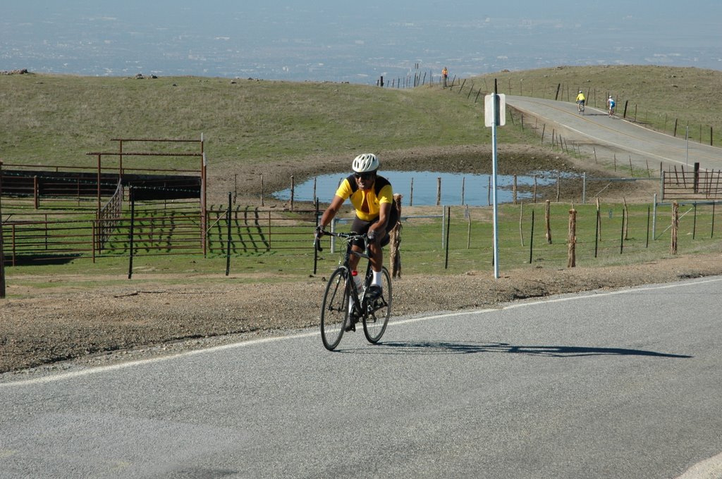
The climb up Page Mill went pretty well. I had done this part of the ride so many times that I knew the road very well. It went along more easily that I was used to, probably because of my excitement and adrenaline. Several people passed me on this stretch, and I only passed a couple others. I warmed up pretty quickly. On one of the flatter sections, I switched from my full-finger gloves to my half-finger gloves while still pedaling.

I settled behind two guys somewhere before the halfway-point of the climb. Their pace was just a little slower that what I thought I could do, but I felt it was best to keep myself limited to that at this early stage.

Just past the halfway-point of the climb, we broke through the fog layer. In the morning everything looked dark and overcast. Vaishali was concerned about the visibility in the hills. But it turned out that the valley was just in a blanket of fog. Above that, it was clear and warmer.

Eventually as we approached the summit, I could no longer take the pace of the guys I was following. I increased my speed and went past them. I reached the summit at Skyline Blvd and continued across on Alpine. This is the point where the 112 and 60 mile routes diverge, so there were fewer cyclists on Alpine.

7:20am, 11 miles, 2280 feet

The downhill ride on Alpine went smoothly. There were very few cars on the road at this time. Once I got back under the fog layer, it started getting cooler. I did not want to put on my jacket because I knew I was getting close to the bottom of the hill, but my hands started getting cold. I need to get the full-finger gloves back on, but there was no way I could do that while speeding downhill. I pulled over to the side and switched them quickly.

Before long I reached the intersection with Pescadero Road. The road started uphill, but fairly quickly got to the entrance to Sam MacDonald Park where the first rest top was. I pulled in and saw that some of the guys who passed me were there. I saw the guy who told me that my gloves were in my pocket. I ate a half banana, some slices of orange and a piece of coffee cake.

8:14am, 19 miles, 2640 feet

I did not want to stay too long and cool off, so I left within 10 minutes. From the park, there was a steady, but not difficult, climb up Pescadero road. After the crest, it was a fast downhill. The fog had burned off by now and it was fairly bright, but it was still early enough that there were still few cars on the road.

Eventually the road leveled off to a more slight grade. As I was nearing the end of the stretch on Pescadero Road, I was passed by the two guys who I rode behind on Page Mill. Just before the town of Pescadero, we turned left towards Butano State Park. The road here is parallel to Highway 1, and is just a little hilly. I caught up to the two guys again once we hit the uphill section. Again, at some point their pace uphill was too slow for me so I passed them.

Before long, the road turned and ended at Highway 1. There were flagmen with the Century helping cyclists turn onto Highway 1 safely. Fairly soon after this point I reached next rest stop at the Costanoa camp ground. There was an even bigger group here than at the last one. I think it was because more people had passed me.

9:11am, 38 miles, 3690 feet

Here again I ate more apple and orange. But for energy this time I had some peanut M&Ms. This time at the facilities I also took off my gloves washed my hands well because they had gotten sticky from sweat and handling the fruit and candy.

Again, I did not want to cool off too much so I left within 15 minutes. As I was leaving Costanoa, I recognized one of the riders who was entering. I used to see him on Caltrain during my commute when I worked at Rearden. At first it struck me as an odd coincidence. But after thinking about it, it probably is not a very big coincidence. Both of brought our bicycles on the train, which means that we are both cyclist. And the Sequoia Century is fairly popular (over 1000 people registered), so it is not too surprising that we are both chose to ride in this event.

The 24 miles on Highway 1 is the longest flat section of the ride. The road does go up and down the sea cliffs a bit, but contain no serious inclines. The northern (first) part of this stretch was much clearer than the rest. I had a tailwind most of the way which made the pedaling on this stretch easier.

Just a few miles after Costanoa, I saw another rest top on Highway 1. This was confusing, but I quickly realized that it was for another event. There were signs on Highway 1 for the AIDS Lifecycle ride (from San Francisco to Los Angeles). That explained why I saw so many more riders on this stretch.

I passed and was passed by fewer people in this stretch since we were all generally cruising at similar speeds (not unusual for a flat stretch). Just before the town of Davenport, I was slowly passed by a woman, and I remained fairly close behind her for a mile or two.

10:15am, 51 miles, 3800 feet

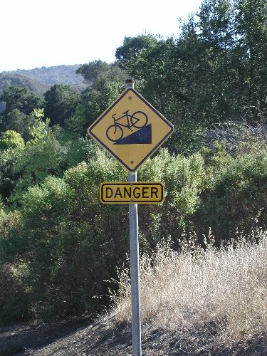
We approached a place where the railroad tracks cross the road. There was a sign put up for the cyclists warning of the tracks. Having ridden on this part of the road before, I felt that the warning should have been bigger and more explicit. Most railroad crossing have the tracks perpendicular to the road. These are not too dangerous, just bumpy. But this particular crossing is treacherous because the tracks are just slightly off the angle of the road.

I slowed down and swerved to the right a little so that I could turn back left and go over the tracks an a perpendicular angle. But I saw that the woman in front of me did not change her angle. I was worried because it looked like a dangerous approach. I was correct because her front wheel got stuck in the track. She went flying and landed hard on the pavement with her bicycle falling on top of her.

I immediately got off my bike, left it by the road side, and ran over to where she was laying. I took the bicycle off her and tossed it to the side. She needed to move because she was laying on the white line that defines the boundary between the road and the shoulder. I was afraid that she may get hit by a car so I immediately began waving my arms and motioning for cars to slow down and go around her.

She was screaming in pain. I told her she needed to move out of the road, but she said she could not move. She remained in the same position as she landed--on her left side and somewhat face-down. I asked her if I could help her move but she said she was in too much pain to move. I thought about moving her myself, but was afraid she may have a fracture that I might aggravate by moving her.

I really did not know what to do next. She needed to move out of the road, but I did not know the best way to do that. Then a car pulled over and two women came by to help. One of them said she was an off-duty paramedic, and it turned out to be good timing that they had come by at that time.

She checked out the rider to see how badly injured she was. After determining that there were no major fractures, the two of us picked her up and moved her all the way to the edge of the shoulder, and by now she was able to sit up on her own.

The paramedic continued to evaluate her. Clearly the cyclist needed medical attention. She offered to call an ambulance for her to take her to Santa Cruz. The cyclist said she preferred to go back to Palo Alto because her parents live there. I told her that I could call the event organizers to see if they could send one of their support vehicles to pick her up. That is what she decided to do since her injuries were not life-threatening.

This whole time there was a decent number of cars and bicycles passing us. At this point, a group of cyclists passed on one caught his rear wheel in the tracks, which sent him crashing to the ground. The paramedic went end attended to him. He landed on his shoulder and smashed it pretty well. But he was able to walk.

It was a very unfortunate result for this guy. He is tourist from Belgium, not a participant in either of the organized rides. He was on his first day of a two week bike tour of the US. It looked like with the extent his shoulder was hurt, it was also be the last day of his trip.

It took about 30 minutes for the support vehicle to arrive. He had a pickup with a bike rack and could easily take both riders back to the starting area in Palo Alto. As we were getting everything prepared on the truck, another woman got her bicycle caught in the tracks and crashed. Fortunately this one was not as serious as the others. She smashed and cut one of her knees. The first two crashes were good advertisements for bicycle helmets. Both of their helmets had large cracks in them, which spared their skulls. Although the third rider might have been able to continue, she decide to not take a chance and just go back with the others. The rack on the truck could take three bicycles, so that is what they did.

After they had left, I was finally ready to continue. I had lost close to an hour because of this episode. All the standing around in the ocean breeze had really cooled me off. So for the first time in the ride, I wore my jacket. The rest of the trip into Santa Cruz was uneventful. I did get hot eventually, but I did not want to stop to take off my jacket. I had lost enough time already, and the third rest stop (the lunch stop) was coming up in Santa Cruz.

Highway 1 enters Santa Cruz and becomes a main street with signal lights. This caused many of the riders that were spaced out to get bunched up into groups. I and the cyclists near me coalesced into a group of 25-30 riders as we got to downtown. But then we encountered a roadblock, literally. There were barriers across the street that we were supposed to ride on our route. There was no construction or emergency, so we did not understand the barriers. So we decided (as much as a mob can) to ride between the barriers and go on the street anyway.

Soon we discovered why the barriers were there -- there was a parade going on. So now we were riding in the parade. We passed a group holding a large banner. I turned back and saw that the sign said "Obama '08". Then we passed a group of men in drag, and more of them along the parade route. They cheered us on. The policemen directing the parade traffic did not seem upset by us riding on the road. I guess it was just an unanticipated scheduling conflict between the ride and the parade and there was no way to change the ride route at this point. Anyway, the overlap was just for three blocks or so. We continued to ride as a group for the remaining mile to the lunch stop.

12:00pm, 65 miles, 4700 feet

There was a large group at this stop. People were staying longer to eat lunch. There was a line to get to the food. As I was standing in line, I realized that I recognized the two women in front of me. They were also familiar faces from Caltrain, just like the guy I saw at Costanoa. I asked them if they rode Caltrain and they said yes. One of them said she vaguely recognized me too. Interestingly, all three of us have since changed jobs and no longer take Caltrain.

I ate lunch with them and we chatted for a while. Their names were Shanna and Megan. It was odd for me to see them together. I would only see Megan in the morning, and only see Shanna in the evening. I had no idea they knew each other.

Usually by this point I am fairly hungry. But since I was able to snack along the way, I ate less than I thought I would. I had a lettuce and cheese sandwich, potato salad, and lots of cookies.

Shanna and Megan left before me. I took a little time after eating to stretch, put away my jacket, and wash my face and hands. I also wanted to let the food settle a little because there was some steep climbing coming up soon. It ended up being a 40 minute break.

I met up with Shanna again at the start of Granite Creek Road. I kept her pace for a little while, but then sped up. Near the end of Granite Creek, I ran into Megan who had stopped to take off her jacket. We rode together for a little while, but I fell behind her on Glenwood. Then I got to Mountain Charlie Road, one of the more famously difficult parts of the route.

1:24pm, 73 miles, 5620 feet

The ride up Mountain Charlie started off well. I passed Megan on one of the steep sections. I was still not having problems with the steeper inclines. At one point, another rider and I kept passing each other. She would pass me on the flatter portions, and I would pass her on the steeper one. The two of us went back and forth several times.

But the sun started bearing down and the accumulated strain of the earlier part of the ride started having an effect. Eventually I started feeling very tired and light-headed. I thought about stopping and resting, but really did not want to. I decided to just slow down my pace. On the sections were the road was flat or downhill, I would just coast and try to build up my strength.

I never got fully exhausted. I did slow down quite a bit. Megan passed me and I did not see her again. From Mountain Charlie, the route went on Summit Dr and Bear Creek. At the intersection of Bear Creek and Skyline Blvd, I found an unmarked rest stop. It was not on the route map. I think it was meant to be a pleasant surprise for the bikers. It was very much needed by me. They had cold soft drinks there. I quickly drank a Sprite. I needed the liquid, the sugar, and the coolness of it. I lingered for 12 minutes to build up my energy.

2:33pm, 81 miles, 7210 feet

I felt a lot better after that. I still had to climb 1000 feet in the next section, but it was over 10 miles, so not a very steep incline. Shanna arrived at the stop just as I was leaving. I started out slowly, but recovered all of my strength on this section of the route, even though it was uphill. Just when I reached the high point of the ride (3100 feet), I had all my energy back.

Of course, this is the point in time when my butt was getting sore. After having spent several hours in the saddle, it hurting from the continuous compression. I kept having to lift myself up while pedaling every few minutes to let it recover for a short time.

Just past the intersection with Highway 9, we had the final rest stop at the fire station. Here again I had banana, orange, and cookies. Since this was the last rest stop and I had had the period of tiredness and also my butt was sore, I rested longer than I normally would have. But now all the big climbs were done, with only two short ones remaining.

On my last training ride when I did this whole route, those last two climbs (Mountain Winery and Mt. Eden Road) were pretty difficult. Normally those are not too hard for me. In fact, I do that route when I do not want too much of a challenge. But I wanted to be sure to have rested up enough by the time I got to them. Again, I saw Shanna as I was leaving the stop.

3:50pm, 92 miles, 8410 feet

The ride down Highway 9 was the fastest part of the route. Since I had been on that road so many times before, I knew it pretty well and could confidently ride fast on it. I passed several other riders, which I rarely do on downhills.

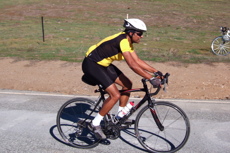
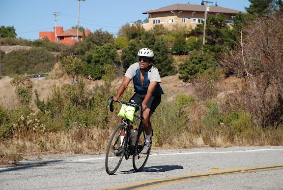
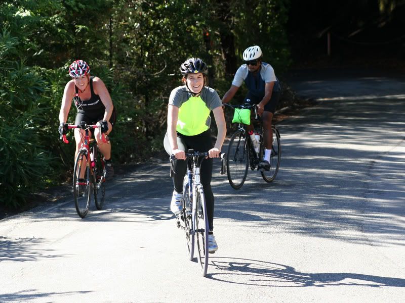
At the bottom of Highway 9 there was the turnoff for Pierce Road and the short climb up to the Mountain Winery. Near the top, there was a camera set up to take pictures of each rider (that is where the picture below was taken). I descended and approached the climb on Mt Eden Road. I started at a slow pace to make sure I could make it over without struggling. This section is steep, but in reality it is not as steep as some of the sections of Page Mill, Summit, and Mountain Charlie. It is just that I was fairly drained at this point. But I actually had no problem -- I did not even have to stand for more power. Probably all the resting and eating is why I was stronger at this point than when I did the training ride.


The rest of the route was the mostly flat return to the Palo Alto VA. I pulled off at Fremont Ave to call Vaishali to schedule my pickup. I had called her a couple times before so she knew I had not had any problems. Shanna passed me about two miles before the VA.

I pulled in back to the registration area around 5:20, which is over 11 hours from when I started that morning. Subtracting all the breaks, it was 8.5 hours on the bicycle. There was an upbeat mood at the finish. They had more food there so I ate pasta salad, potato salad, more pasta salad, and cookies. The ice cream sandwiches were very popular, but I did not have any.

A couple guys congratulated me on the strong finish. They said they were behind me for much of the last stretch. I felt embarrassed that I did not recognize or remember them. Of course, I probably stood out a little more than most since there were very few non-whites and non-East-Asians. I was also identifiable because I wore cargo short over my biking shorts. I talked more with one of the guys who said he was with me. I then recognized him by his bicycle. We chatted for a bit then I chatted with Shanna.

5:25pm, 112 miles, 9020 feet

Vaishali and Rucha then came by so we loaded up the bike, I changed into a clean shirt, and we left. We picked up pizza on the way home. Usually after a ride I am famished and eat like a glutton. But because I had the chance to eat so much along the way and at the finish, I did not eat that much at home.

I felt pretty good that evening considering the exertion I had endured. But by 8:00 I could no longer keep myself awake. I had a long sleep. The next day I had a headache and a stiff neck, but no serious problems. Then I started thinking about some of the other centuries that are scheduled for later this summer ...